Home > Europe > Greece > Aerial Views
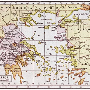
Map of Greek regions under Macedonian rule, 3rd century BC, drawing

![]()
Wall Art and Photo Gifts from Universal Images Group (UIG)
Map of Greek regions under Macedonian rule, 3rd century BC, drawing
Cartography - Greek civilization. Map of Greek regions under Macedonian rule in the 3rd century b.C. Color illustration
Universal Images Group (UIG) manages distribution for many leading specialist agencies worldwide
Media ID 9516853
Aegean Sea Aerial View Ancient Greece Drawing Greece Macedonian Ancient Civilizations
FEATURES IN THESE COLLECTIONS
> Europe
> Greece
> Aerial Views
> Universal Images Group (UIG)
> Art
> Archeology
EDITORS COMMENTS
This print showcases a remarkable piece of history - the "Map of Greek regions under Macedonian rule, 3rd century BC". With its vibrant colors and intricate details, this drawing takes us back to ancient Greece and offers a unique glimpse into the past. The map depicts the various Greek regions that were under Macedonian control during the 3rd century BC. It highlights how far-reaching Alexander the Great's empire had become, extending from Macedonia in northern Greece all the way to Egypt and India. The Aegean Sea stands out prominently, serving as a reminder of Greece's maritime prowess during this period. From an aerial view perspective, we can appreciate the meticulous cartography skills employed by ancient Greeks. Every line and contour on this square image has been carefully drawn to accurately represent each region's topography. As we delve into this illustration and painting, it becomes evident that no people are present. This absence allows us to focus solely on understanding historical context rather than being distracted by individual stories or events. Transporting us back over two millennia ago, this map serves as an invaluable tool for studying ancient civilizations. Its preservation reminds us of our rich cultural heritage while offering insights into political boundaries and territorial expansions during one of Greece's most significant periods
MADE IN THE USA
Safe Shipping with 30 Day Money Back Guarantee
FREE PERSONALISATION*
We are proud to offer a range of customisation features including Personalised Captions, Color Filters and Picture Zoom Tools
SECURE PAYMENTS
We happily accept a wide range of payment options so you can pay for the things you need in the way that is most convenient for you
* Options may vary by product and licensing agreement. Zoomed Pictures can be adjusted in the Cart.