Home > Arts > Artists > A > Battista Agnese
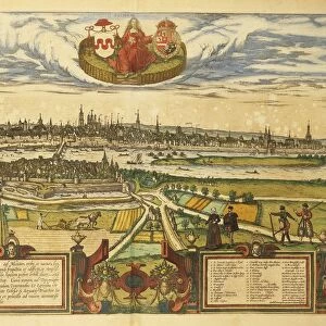
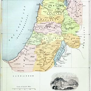
Holy Land, Israel and Palestine, from Atlas of the World in thirty-three Maps, by Battista Agnese, 1553

![]()
Wall Art and Photo Gifts from Universal Images Group (UIG)
Holy Land, Israel and Palestine, from Atlas of the World in thirty-three Maps, by Battista Agnese, 1553
Cartography, 16th century. The Holy Land, Israel and Palestine, from Atlas of the World in thirty-three Maps, by Battista Agnese, 1553
Universal Images Group (UIG) manages distribution for many leading specialist agencies worldwide
Media ID 9572651
© DEA / A. DAGLI ORTI
16th Century Agnese Battista Israel Palestine Holy Land
FEATURES IN THESE COLLECTIONS
> Arts
> Artists
> A
> Battista Agnese
> Universal Images Group (UIG)
> Art
> Painting, Sculpture & Prints
> Cartography
EDITORS COMMENTS
This 16th-century print takes us on a journey back in time to the Holy Land, offering a glimpse into the ancient landscapes of Israel and Palestine. Created by Battista Agnese in 1553, this antique map is a testament to the artistry and precision of cartography during the Renaissance era. The intricate details and vibrant colors bring this historical piece to life, showcasing Agnese's mastery as an illustrator and painter. The horizontal composition allows us to explore every corner of this sacred region, from its rolling hills and winding rivers to its bustling cities and holy sites. With no people present in the image, our focus is solely on the geographical features that have shaped centuries of history. This print serves as a window into a world long gone but not forgotten – reminding us of the rich heritage that lies within these lands. As we gaze upon this remarkable artifact, we are transported through time, contemplating how much has changed since Agnese first crafted this masterpiece over four centuries ago. It stands as both an educational tool for understanding past civilizations and an exquisite work of art that continues to captivate viewers today
MADE IN THE USA
Safe Shipping with 30 Day Money Back Guarantee
FREE PERSONALISATION*
We are proud to offer a range of customisation features including Personalised Captions, Color Filters and Picture Zoom Tools
SECURE PAYMENTS
We happily accept a wide range of payment options so you can pay for the things you need in the way that is most convenient for you
* Options may vary by product and licensing agreement. Zoomed Pictures can be adjusted in the Cart.