Home > Arts > Landscape paintings > Waterfall and river artworks > River artworks
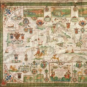
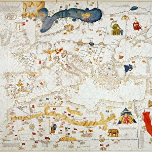
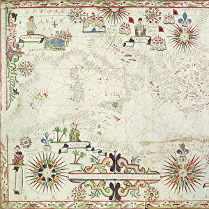
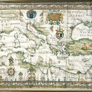
The Maghreb and the Middle East, Ottoman miniature

![]()
Wall Art and Photo Gifts from Universal Images Group (UIG)
The Maghreb and the Middle East, Ottoman miniature
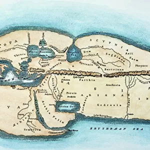
Cartography, late 16th century. The Maghreb and the Middle East. Ottoman miniature
Universal Images Group (UIG) manages distribution for many leading specialist agencies worldwide
Media ID 9502235
© DEA / G. DAGLI ORTI
16th Century Arabic Script Coastline Galata Maghreb Mediterranean Sea Miniature Ottoman Empire River Townscape Animal Representation Turkish Culture
FEATURES IN THESE COLLECTIONS
> Architecture
> Styles
> Empire Architecture
> Architecture
> Styles
> Mediterranean Architecture
> Arts
> Landscape paintings
> Waterfall and river artworks
> River artworks
> Universal Images Group (UIG)
> Art
> Painting, Sculpture & Prints
> Cartography
EDITORS COMMENTS
This print showcases a remarkable Ottoman miniature from the late 16th century, depicting "The Maghreb and the Middle East". This exquisite piece of cartography art offers a fascinating glimpse into the intricate world of mapmaking during that era. The horizontal composition presents an expansive view of the Ottoman Empire, stretching across vast lands and encompassing diverse cultures. The Mediterranean Sea gracefully curves along the coastline, serving as a vital lifeline for trade and communication between nations. Intricate details bring this miniature to life, with townscape architecture meticulously depicted in vibrant colors. From bustling cities like Galata to serene rivers meandering through lush landscapes, every element is intricately portrayed. Arabic script adorns various parts of the map, adding an authentic touch to this masterpiece. It serves as a reminder of the rich cultural heritage and influence that Turkish culture had on this region during that time. Notably absent are human representations within this artwork; however, animal depictions add charm and character to certain areas. These artistic choices provide insight into both historical context and aesthetic preferences prevalent during Ottoman times. Overall, this stunning print captures not only geographical accuracy but also reflects the artistic prowess of its creator. It stands as a testament to how art intertwines with cartography in creating visually striking representations of our world's history.
MADE IN THE USA
Safe Shipping with 30 Day Money Back Guarantee
FREE PERSONALISATION*
We are proud to offer a range of customisation features including Personalised Captions, Color Filters and Picture Zoom Tools
SECURE PAYMENTS
We happily accept a wide range of payment options so you can pay for the things you need in the way that is most convenient for you
* Options may vary by product and licensing agreement. Zoomed Pictures can be adjusted in the Cart.