Home > Arts > Artists > O > Abraham Ortelius
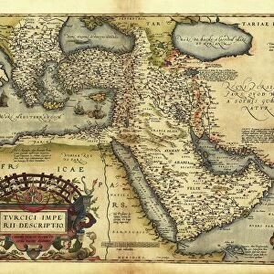
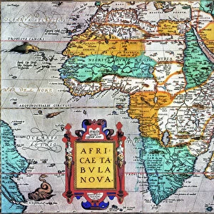
Map of Bavaria, Germany, from Theatrum Orbis Terrarum by Abraham Ortelius, 1528-1598, 1570

![]()
Wall Art and Photo Gifts from Universal Images Group (UIG)
Map of Bavaria, Germany, from Theatrum Orbis Terrarum by Abraham Ortelius, 1528-1598, 1570
Cartography, Germany, 16th century. Map of Bavaria, from Theatrum Orbis Terrarum by Abraham Ortelius (1528-1598), Antwerp, 1570
Universal Images Group (UIG) manages distribution for many leading specialist agencies worldwide
Media ID 9572599
© DEA / A. DAGLI ORTI
1570 16th Century Abraham Ortelius Aerial View Bavaria Border Direction Germany Guidance Hydrography Latin Script Mountain Mountain Range Navigational Equipment River Text Theatrum Orbis Terrarum Non Urban Scene River Danube
FEATURES IN THESE COLLECTIONS
> Aerial Photography
> Germany
> Arts
> Art Movements
> Landscapes
> Arts
> Artists
> O
> Abraham Ortelius
> Arts
> Contemporary art
> Landscapes
> Sculptures
> Arts
> Contemporary art
> Sculpture
> Landscape paintings
> Arts
> Landscape paintings
> Landscape art
> Landscape paintings
> Arts
> Landscape paintings
> Landscape art
> Arts
> Landscape paintings
> Waterfall and river artworks
> Landscape paintings
> Arts
> Landscape paintings
> Waterfall and river artworks
> River artworks
> Maps and Charts
> Abraham Ortelius
> Universal Images Group (UIG)
> Art
> Painting, Sculpture & Prints
> Cartography
EDITORS COMMENTS
This print showcases a remarkable piece of cartography from the 16th century. The image features a Map of Bavaria, Germany, meticulously crafted by Abraham Ortelius for his renowned work, Theatrum Orbis Terrarum. Created in Antwerp in 1570, this map offers an extraordinary glimpse into the past and provides valuable insights into the topography and physical geography of Bavaria during that era. The map's intricate details beautifully capture the majestic landscape of Bavaria with its sprawling mountains and meandering rivers. The River Danube gracefully winds through the region, adding to its natural charm. With Latin script carefully inscribed across the map, it serves as both a navigational tool and an artistic masterpiece. As we delve into this historical artifact, we are transported back in time to explore a non-urban scene devoid of people but brimming with artistry and craftsmanship. This aerial view allows us to appreciate how Ortelius skillfully depicted every mountain range, river course, and border within Bavaria. With its horizontal orientation and clear text guiding our eyes across the map's surface, this print invites us on a journey through time as we uncover centuries-old landscapes while marveling at Ortelius' mastery in capturing such detailed representations. Whether you are an enthusiast of cartography or simply intrigued by history's treasures, this print is sure to captivate your imagination with its rich depiction of Bavarian topography from centuries ago.
MADE IN THE USA
Safe Shipping with 30 Day Money Back Guarantee
FREE PERSONALISATION*
We are proud to offer a range of customisation features including Personalised Captions, Color Filters and Picture Zoom Tools
SECURE PAYMENTS
We happily accept a wide range of payment options so you can pay for the things you need in the way that is most convenient for you
* Options may vary by product and licensing agreement. Zoomed Pictures can be adjusted in the Cart.