Home > Europe > France > Paris > Maps
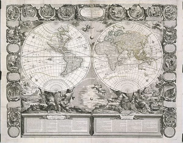
A map of the Earth divided into two hemispheres by Jean-Baptiste Nolin, colored copperplate, printed in Paris, 1700
![]()

Wall Art and Photo Gifts from Universal Images Group (UIG)
A map of the Earth divided into two hemispheres by Jean-Baptiste Nolin, colored copperplate, printed in Paris, 1700
Cartography, 18th century. A map of the Earth divided into two hemispheres. Designed by Jean-Baptiste Nolin. Paris, 1700. Illuminated colored copperplate. 125 x 160 cm
Universal Images Group (UIG) manages distribution for many leading specialist agencies worldwide
Media ID 9572591
© DEA PICTURE LIBRARY
18th Century Background People Copperplate Direction Globe Guidance Western Script
FEATURES IN THESE COLLECTIONS
> Europe
> France
> Paris
> Maps
> Universal Images Group (UIG)
> Art
> Painting, Sculpture & Prints
> Cartography
EDITORS COMMENTS
This stunning copperplate print, created by Jean-Baptiste Nolin in Paris in 1700, showcases a map of the Earth divided into two hemispheres. With its intricate details and vibrant colors, this piece of cartography from the 18th century is a true masterpiece. Measuring at an impressive size of 125 x 160 cm, this illuminated print captures the essence of exploration and discovery during that era. It serves as a visual representation of how people perceived the world back then, with Western script labeling various continents and oceans. The map not only provides geographical information but also evokes a sense of direction and guidance for travelers. Its historical significance lies in its ability to transport us back to a time when mapping out uncharted territories was both challenging and exciting. Displayed against a backdrop devoid of any human presence, this artwork invites viewers to immerse themselves in the wonders that our planet holds. The attention to detail is evident as every contour line and body of water has been meticulously depicted. As we gaze upon this horizontal composition under natural daylight, we are reminded of the importance placed on physical geography during those times. This illustration beautifully combines artistry with scientific accuracy, making it an invaluable artifact for enthusiasts interested in both history and cartography
MADE IN THE USA
Safe Shipping with 30 Day Money Back Guarantee
FREE PERSONALISATION*
We are proud to offer a range of customisation features including Personalised Captions, Color Filters and Picture Zoom Tools
SECURE PAYMENTS
We happily accept a wide range of payment options so you can pay for the things you need in the way that is most convenient for you
* Options may vary by product and licensing agreement. Zoomed Pictures can be adjusted in the Cart.

