Home > Europe > Italy > Maps
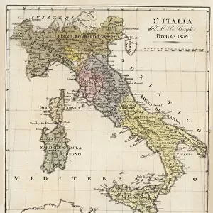
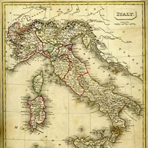
Map of Italy in 1743

![]()
Wall Art and Photo Gifts from Universal Images Group (UIG)
Map of Italy in 1743
Cartography, 18th century. Map of Italy in 1743
Universal Images Group (UIG) manages distribution for many leading specialist agencies worldwide
Media ID 9573037
© DEA / A. DE GREGORIO
18th Century Island Peninsula Western Script
FEATURES IN THESE COLLECTIONS
> Europe
> Italy
> Sculptures
> Universal Images Group (UIG)
> Art
> Painting, Sculpture & Prints
> Cartography
EDITORS COMMENTS
This print takes us on a journey back in time to the 18th century, immersing us in the world of cartography. The Map of Italy in 1743 is a remarkable piece of artistry and historical significance. With its full-length depiction, it showcases the intricate details of Italy's geography during that era. The map itself is an exquisite illustration and painting, meticulously crafted with precision and care. It beautifully captures the physical geography of Italy, from its iconic peninsula shape to the surrounding islands that dot its coastline. The use of western script adds an authentic touch, reminding us of the language used by scholars and explorers during this period. As we gaze upon this studio shot photograph, we can't help but marvel at how far our understanding of maps has come since then. This single object encapsulates centuries worth of knowledge about Italy's past and serves as a testament to human curiosity and exploration. While there are no people featured in this image, it invites us to reflect on our place within history and how these maps have shaped our understanding of the world around us. Whether you're a lover of history or simply appreciate fine craftsmanship, this print offers a glimpse into an era long gone yet still preserved for generations to come.
MADE IN THE USA
Safe Shipping with 30 Day Money Back Guarantee
FREE PERSONALISATION*
We are proud to offer a range of customisation features including Personalised Captions, Color Filters and Picture Zoom Tools
SECURE PAYMENTS
We happily accept a wide range of payment options so you can pay for the things you need in the way that is most convenient for you
* Options may vary by product and licensing agreement. Zoomed Pictures can be adjusted in the Cart.