Home > Arts > Artists > O > Abraham Ortelius
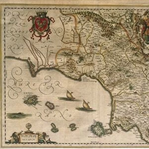
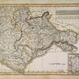
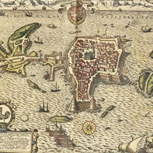
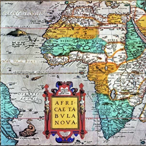
Map of the Kingdom of Naples, Italy, from Theatrum Orbis Terrarum by Abraham Ortelius, 1528-1598, 1570

![]()
Wall Art and Photo Gifts from Universal Images Group (UIG)
Map of the Kingdom of Naples, Italy, from Theatrum Orbis Terrarum by Abraham Ortelius, 1528-1598, 1570
Cartography, Italy, 16th century. Map of the Kingdom of Naples, from Theatrum Orbis Terrarum by Abraham Ortelius (1528-1598), Antwerp, 1570
Universal Images Group (UIG) manages distribution for many leading specialist agencies worldwide
Media ID 9590715
© DEA / A. DAGLI ORTI
1570 16th Century Abraham Ortelius Aerial View Apulia Banner Basilicata Calabria Campania Coastline Compass Direction Guidance Island Journey Latin Script Mediterranean Sea Naples Nautical Vessel Navigational Equipment Sailing Ship Ship Text Theatrum Orbis Terrarum Non Urban Scene
FEATURES IN THESE COLLECTIONS
> Arts
> Art Movements
> Landscapes
> Arts
> Artists
> O
> Abraham Ortelius
> Arts
> Contemporary art
> Landscapes
> Sculptures
> Arts
> Contemporary art
> Sculpture
> Landscape paintings
> Arts
> Landscape paintings
> Landscape art
> Landscape paintings
> Arts
> Landscape paintings
> Landscape art
> Arts
> Street art graffiti
> Urban art
> Landscape paintings
> Europe
> Italy
> Aerial Views
> Maps and Charts
> Abraham Ortelius
> Universal Images Group (UIG)
> Art
> Painting, Sculpture & Prints
> Cartography
EDITORS COMMENTS
This print showcases a remarkable piece of cartographic history - the "Map of the Kingdom of Naples, Italy" from Abraham Ortelius' renowned work, Theatrum Orbis Terrarum. Created in 1570, this exquisite map provides a fascinating glimpse into the topography and physical geography of 16th-century Italy. The aerial view reveals an expansive landscape encompassing Calabria, Naples, Campania, Apulia, and Basilicata. With its intricate details and Latin script annotations, this map served as both a navigational tool and a work of art during its time. A sailing ship gracefully glides across the Mediterranean Sea in this horizontal composition. Its presence evokes thoughts of exploration and adventure that were prevalent during the Age of Discovery. As we gaze upon this historical gem, we can almost imagine ourselves embarking on a grand journey to these enchanting Italian regions. The vibrant colors used in this illustration add depth to the coastline's contours while highlighting key features such as water bodies and mountain ranges. A compass rose elegantly guides our eyes towards cardinal directions while reminding us of the importance placed on accurate navigation centuries ago. With no people present within the frame, we are left to appreciate solely the craftsmanship behind Ortelius' masterpiece. This print serves as a testament to his skillful cartography and artistic vision - an enduring tribute to an era long past but forever preserved through his meticulous workmanship.
MADE IN THE USA
Safe Shipping with 30 Day Money Back Guarantee
FREE PERSONALISATION*
We are proud to offer a range of customisation features including Personalised Captions, Color Filters and Picture Zoom Tools
SECURE PAYMENTS
We happily accept a wide range of payment options so you can pay for the things you need in the way that is most convenient for you
* Options may vary by product and licensing agreement. Zoomed Pictures can be adjusted in the Cart.