Home > Arts > Artists > H > Franz Hogenberg
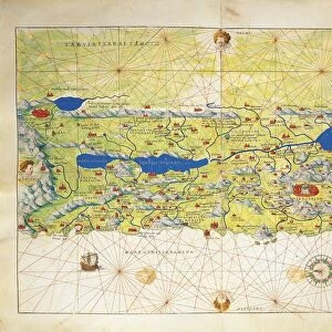
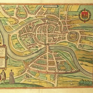
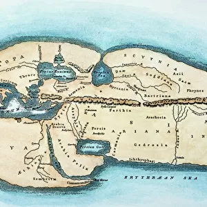
Map of Mstricht from Civitates Orbis Terrarum by Georg Braun, 1541-1622 and Franz Hogenberg, 1540-1590, engraving

![]()
Wall Art and Photo Gifts from Universal Images Group (UIG)
Map of Mstricht from Civitates Orbis Terrarum by Georg Braun, 1541-1622 and Franz Hogenberg, 1540-1590, engraving
Cartography, Netherlands, 16th century. Map of Mstricht. From Civitates Orbis Terrarum by Georg Braun (1541-1622) and Franz Hogenberg (1540-1590), Cologne. Engraving
Universal Images Group (UIG) manages distribution for many leading specialist agencies worldwide
Media ID 9572671
© DEA / R. MERLO
16th Century Coat Of Arms Elevated View Horizon Over Land Manuscript Netherlands River Text Townscape Maastricht
FEATURES IN THESE COLLECTIONS
> Arts
> Art Movements
> Landscapes
> Arts
> Artists
> H
> Franz Hogenberg
> Arts
> Contemporary art
> Landscapes
> Sculptures
> Arts
> Contemporary art
> Sculpture
> Landscape paintings
> Arts
> Landscape paintings
> Landscape art
> Landscape paintings
> Arts
> Landscape paintings
> Landscape art
> Arts
> Landscape paintings
> Waterfall and river artworks
> Landscape paintings
> Arts
> Landscape paintings
> Waterfall and river artworks
> River artworks
> Europe
> Netherlands
> Maastricht
> Universal Images Group (UIG)
> Art
> Painting, Sculpture & Prints
> Cartography
EDITORS COMMENTS
This print showcases a remarkable piece of cartographic history - the "Map of Mstricht" from the renowned Civitates Orbis Terrarum by Georg Braun and Franz Hogenberg. Created between 1541 and 1622, this engraving offers a fascinating glimpse into the Netherlands during the 16th century. The map itself is a true work of art, meticulously crafted with intricate details that transport us back in time. The townscape of Maastricht unfolds before our eyes, revealing its rich history and physical geography. From an elevated view, we witness the landscape stretching out beneath a vast sky, capturing both natural beauty and human representation. The composition is masterfully executed, with every stroke conveying depth and perspective. As we explore this historical artifact, our attention is drawn to various elements such as coat of arms, text manuscripts, and even a river flowing through the cityscape. This studio shot allows us to appreciate the fine craftsmanship behind this engraving while preserving its originality. It serves as a reminder that maps are not merely functional tools but also works of art that tell stories about our world's past. As we gaze upon this mesmerizing image captured by Universal Images Group (UIG), we are reminded of how cartography has evolved over centuries yet continues to captivate us with its ability to depict both factual information and artistic expression.
MADE IN THE USA
Safe Shipping with 30 Day Money Back Guarantee
FREE PERSONALISATION*
We are proud to offer a range of customisation features including Personalised Captions, Color Filters and Picture Zoom Tools
SECURE PAYMENTS
We happily accept a wide range of payment options so you can pay for the things you need in the way that is most convenient for you
* Options may vary by product and licensing agreement. Zoomed Pictures can be adjusted in the Cart.