Home > Europe > Italy > Maps
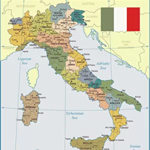
Map of Papal States, Italy, 1783

![]()
Wall Art and Photo Gifts from Universal Images Group (UIG)
Map of Papal States, Italy, 1783
Cartography, Italy, 18th century. Map of the Papal States, 1783
Universal Images Group (UIG) manages distribution for many leading specialist agencies worldwide
Media ID 9572765
© DEA / A. DE GREGORIO
18th Century Emilia Romagna Region Guidance Italian Culture Western Script
FEATURES IN THESE COLLECTIONS
> Europe
> Italy
> Emilia-Romagna
> Related Images
> Europe
> Italy
> Sculptures
> Universal Images Group (UIG)
> Art
> Painting, Sculpture & Prints
> Cartography
EDITORS COMMENTS
This print showcases a remarkable piece of history - the Map of Papal States, Italy in 1783. Created during the 18th century, this exquisite cartographic masterpiece offers a glimpse into the political and geographical landscape of that era. The map, meticulously crafted with intricate details and precision, reflects both the artistry and scientific knowledge prevalent at the time. In this studio shot, we are presented with an expertly preserved illustration that highlights the boundaries and regions of the Papal States. With its horizontal orientation, it allows us to delve into Italian culture while tracing historical developments within this significant period. The absence of people in this image directs our focus solely on appreciating the craftsmanship behind this invaluable artifact. Western script adorns various locations on the map, providing further insight into regional names and landmarks within Emilia Romagna region. As we explore every corner of this ancient document through our eyes, we can't help but feel a sense of guidance as if being transported back to an era where maps were essential tools for navigation and exploration. This photograph serves as a testament to human curiosity about our surroundings throughout history. While not intended for commercial use by Universal Images Group (UIG), their dedication to preserving such cultural treasures ensures that future generations can continue to marvel at these valuable pieces from centuries past.
MADE IN THE USA
Safe Shipping with 30 Day Money Back Guarantee
FREE PERSONALISATION*
We are proud to offer a range of customisation features including Personalised Captions, Color Filters and Picture Zoom Tools
SECURE PAYMENTS
We happily accept a wide range of payment options so you can pay for the things you need in the way that is most convenient for you
* Options may vary by product and licensing agreement. Zoomed Pictures can be adjusted in the Cart.