Home > Europe > Italy > Sicily > Palermo
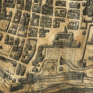
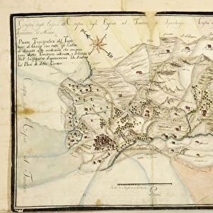
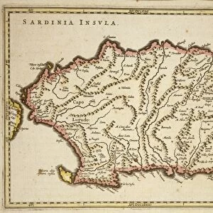
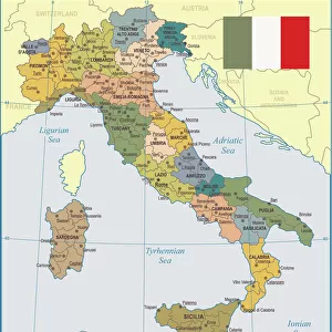
Topographic map of area of Partinico, Palermo province, Sicily region

![]()
Wall Art and Photo Gifts from Universal Images Group (UIG)
Topographic map of area of Partinico, Palermo province, Sicily region
Cartography, Italy, 19th century. Topographic map of the area of Partinico, Palermo province, Sicily region
Universal Images Group (UIG) manages distribution for many leading specialist agencies worldwide
Media ID 9502091
© DEA / G. NIMATALLAH
Palermo Province Sicily Western Script
FEATURES IN THESE COLLECTIONS
> Europe
> Italy
> Sculptures
> Europe
> Italy
> Sicily
> Palermo
> Universal Images Group (UIG)
> Art
> Painting, Sculpture & Prints
> Cartography
EDITORS COMMENTS
This print showcases a topographic map of the Partinico area in the Palermo province, located within the beautiful region of Sicily, Italy. Dating back to the 19th century, this meticulously crafted cartography piece offers an intriguing glimpse into the past. The full-length studio shot captures every intricate detail of this historical map. The horizontal composition allows us to appreciate its physical geography and highlights various landmarks that shaped Partinico's landscape during that era. A majestic tree stands tall amidst the carefully illustrated buildings and exteriors, adding a touch of natural beauty to this artistic creation. With no people present in the image, our focus is solely on unraveling the rich history embedded within these Western script markings. This remarkable artifact serves as a testament to human ingenuity and craftsmanship from bygone times. As we delve into this visual masterpiece, it becomes evident that it represents more than just geographical information; it symbolizes an era when cartography was considered both an art form and a scientific endeavor. Its presence invites us to reflect upon how our understanding of maps has evolved over time while appreciating their enduring significance. This extraordinary print from Universal Images Group (UIG) transports us back in time, allowing us to explore Partinico's past through a unique blend of artistry and geographic precision. It serves as a reminder of how historical artifacts can connect us with our roots and deepen our appreciation for cultural heritage.
MADE IN THE USA
Safe Shipping with 30 Day Money Back Guarantee
FREE PERSONALISATION*
We are proud to offer a range of customisation features including Personalised Captions, Color Filters and Picture Zoom Tools
SECURE PAYMENTS
We happily accept a wide range of payment options so you can pay for the things you need in the way that is most convenient for you
* Options may vary by product and licensing agreement. Zoomed Pictures can be adjusted in the Cart.