Home > Europe > United Kingdom > England > Sculptures
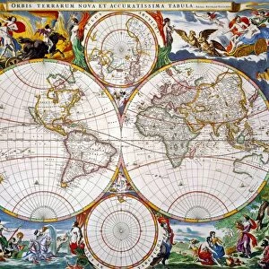
Map of Nova Belgica or New Belgium and of Anglia Nova or New England by Willem Janszoon Blaeu, 1663

![]()
Wall Art and Photo Gifts from Universal Images Group (UIG)
Map of Nova Belgica or New Belgium and of Anglia Nova or New England by Willem Janszoon Blaeu, 1663
Cartography, America, 17th century. Willem Janszoon Blaeu, map of Nova Belgica or New Belgium and of Anglia Nova or New England, 1663
Universal Images Group (UIG) manages distribution for many leading specialist agencies worldwide
Media ID 9572683
© DEA / C. BEVILACQUA
17th Century America Coastline Geography New England Ship Cartography And Historic Topography Willem Janszoon Blaeu
FEATURES IN THESE COLLECTIONS
> Europe
> Belgium
> Paintings
> Europe
> Belgium
> Sculptures
> Europe
> United Kingdom
> England
> Maps
> Europe
> United Kingdom
> England
> Paintings
> Europe
> United Kingdom
> England
> Sculptures
> Maps and Charts
> Willem Janszoon Blaeu
> Universal Images Group (UIG)
> Art
> Painting, Sculpture & Prints
> Illustration And Painting
EDITORS COMMENTS
This print showcases a remarkable piece of cartography from the 17th century. The Map of Nova Belgica or New Belgium and of Anglia Nova or New England, created by Willem Janszoon Blaeu in 1663, takes us on a journey through time and space. With its intricate details and exquisite craftsmanship, this map transports us to an era when exploration was at its peak. It offers a glimpse into the geographical knowledge and understanding of America during that period. The horizontal layout allows for a comprehensive view of the vast coastline, highlighting both New Belgium and New England. As we delve into this historic topography, we are reminded of the importance of maritime navigation during those times. Ships gracefully sail across the sea depicted on the map, symbolizing the adventurous spirit that characterized this era. The absence of people in this illustration emphasizes our focus on geography rather than human presence. It invites us to appreciate nature's beauty as it unfolds along these coastlines. Willem Janszoon Blaeu's expertise shines through every stroke in this artwork. His attention to detail brings life to each contour line and landmass represented on the map. This print is not only a testament to Blaeu's talent but also serves as a window into history itself—an invaluable artifact that captures both our curiosity about past explorations and our admiration for artistry in cartography.
MADE IN THE USA
Safe Shipping with 30 Day Money Back Guarantee
FREE PERSONALISATION*
We are proud to offer a range of customisation features including Personalised Captions, Color Filters and Picture Zoom Tools
SECURE PAYMENTS
We happily accept a wide range of payment options so you can pay for the things you need in the way that is most convenient for you
* Options may vary by product and licensing agreement. Zoomed Pictures can be adjusted in the Cart.