Home > Universal Images Group (UIG) > Art > Painting, Sculpture & Prints > Illustration And Painting
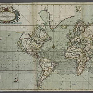
Universal trade map, planisphere with the routes of navigation to Eastern and Western Indies, engraving, 1686

![]()
Wall Art and Photo Gifts from Universal Images Group (UIG)
Universal trade map, planisphere with the routes of navigation to Eastern and Western Indies, engraving, 1686
Cartography, 17th century. Universal trade map, planisphere with the routes of navigation to Eastern and Western Indies, 1686. Engraving
Universal Images Group (UIG) manages distribution for many leading specialist agencies worldwide
Media ID 9572083
© DEA / D. DAGLI ORTI
17th Century Geography Guidance Navigation World Map
EDITORS COMMENTS
This print showcases a remarkable piece of cartography from the 17th century - a universal trade map, planisphere with the routes of navigation to Eastern and Western Indies. Engraved in 1686 by Pierre Duval, this antique masterpiece takes us back in time to an era when exploration and trade across vast oceans were at their peak. The intricate details on this map offer a glimpse into the geographical knowledge and navigational expertise of that period. It presents an expansive view of the world, highlighting both Eastern and Western Indies as crucial destinations for global commerce. The carefully etched routes of navigation serve as valuable guidance for sailors who braved treacherous seas in search of new lands and lucrative trading opportunities. With its horizontal layout, this illustration provides a comprehensive overview of our planet's geography during the 17th century. Its historical significance cannot be overstated, as it represents not only an invaluable tool for seafarers but also a testament to human curiosity and ambition. Although devoid of people, this image transports us through time, allowing us to appreciate the immense efforts made by early explorers who shaped our understanding of the world. As we gaze upon this vintage engraving, we are reminded that history is intricately woven into every inch of its surface – beckoning us to explore further into humanity's past while marveling at the beauty and complexity captured within these ancient lines.
MADE IN THE USA
Safe Shipping with 30 Day Money Back Guarantee
FREE PERSONALISATION*
We are proud to offer a range of customisation features including Personalised Captions, Color Filters and Picture Zoom Tools
SECURE PAYMENTS
We happily accept a wide range of payment options so you can pay for the things you need in the way that is most convenient for you
* Options may vary by product and licensing agreement. Zoomed Pictures can be adjusted in the Cart.