Home > Africa > Related Images
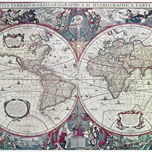
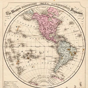
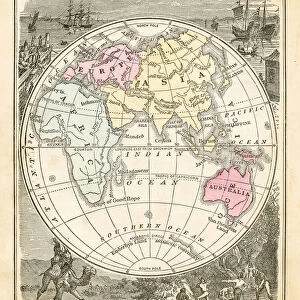
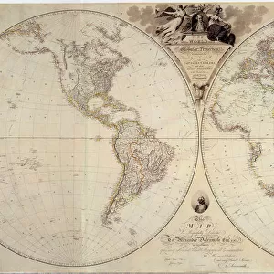
Double-Hemisphere Map 1542

![]()
Wall Art and Photo Gifts from Universal Images Group (UIG)
Double-Hemisphere Map 1542
Universal Images Group (UIG) manages distribution for many leading specialist agencies worldwide
Media ID 20165345
Africa America Antiquarian Antiquarian Maps Earth Globe Journey Journeys Maps South Travels Treks Trip Trips Voyage Voyages World 1542 Detailed Double Hemisphere Shapeless
FEATURES IN THESE COLLECTIONS
> Africa
> Related Images
> Universal Images Group (UIG)
> History
> Historical Maps
EDITORS COMMENTS
This print showcases a remarkable piece of history - the Double-Hemisphere Map from 1542. Stepping into the past, this antique map takes us on a visual journey through time and space. With intricate details and meticulous craftsmanship, it offers a glimpse into how our ancestors perceived the world. The map's double-hemisphere design presents an intriguing perspective of Earth's continents, including Africa and America. As we explore its faded lines and faded colors, we can't help but marvel at the level of skill required to create such an accurate representation with limited resources. However, upon closer examination, one may notice certain misrepresentations that reflect the limitations of geographical knowledge during that era. The shapeless South American continent is particularly striking, reminding us of how much progress has been made in cartography since then. This antiquarian treasure serves as a reminder of humanity's insatiable curiosity for exploration and discovery. It symbolizes countless voyages undertaken by intrepid travelers who embarked on treks across uncharted territories in search of new horizons. As we gaze upon this old-world masterpiece captured in print form by PicturesNow UIG from Universal Images Group (UIG), we are transported back to an era when maps were not just tools for navigation but also works of art that ignited wanderlust within those who beheld them.
MADE IN THE USA
Safe Shipping with 30 Day Money Back Guarantee
FREE PERSONALISATION*
We are proud to offer a range of customisation features including Personalised Captions, Color Filters and Picture Zoom Tools
SECURE PAYMENTS
We happily accept a wide range of payment options so you can pay for the things you need in the way that is most convenient for you
* Options may vary by product and licensing agreement. Zoomed Pictures can be adjusted in the Cart.