Home > Universal Images Group (UIG) > History > Historical Maps
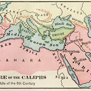
Map of the Muslim expansion and the Byzantine Empire at the end of the Umayyad Caliphate, in 750

![]()
Wall Art and Photo Gifts from Universal Images Group (UIG)
Map of the Muslim expansion and the Byzantine Empire at the end of the Umayyad Caliphate, in 750
Map of the Muslim expansion and the Byzantine Empire at the end of the Umayyad Caliphate, in 750. From Historical Atlas, published 1923
Universal Images Group (UIG) manages distribution for many leading specialist agencies worldwide
Media ID 20165127
© Ken Welsh / Design Pics
Byzantine Century Chart Countries Country Eighth Empire Expansion Geographical Geography Muslim Caliphate Umayyad
EDITORS COMMENTS
This print showcases a historical map depicting the Muslim expansion and the Byzantine Empire at the close of the Umayyad Caliphate in 750. Published in 1923 as part of the Historical Atlas, this map offers a glimpse into an era that shaped both Islamic and Byzantine history. The intricate details on this chart provide valuable insights into the geographical extent of these empires during the eighth century. It highlights not only political boundaries but also serves as a testament to cultural exchanges, conquests, and religious transformations that took place during this period. As we observe this map, we witness how vast territories were brought under Muslim rule while remnants of the once-mighty Byzantine Empire struggled to maintain their influence. The contrasting colors demarcating different countries serve as visual reminders of power dynamics and territorial shifts. This image invites us to delve deeper into history, sparking curiosity about significant events such as battles fought, alliances forged, and civilizations flourishing amidst changing landscapes. It prompts reflection on how these developments continue to shape our present-day world. Preserved by Universal History Archive from Universal Images Group (UIG), this print serves as a reminder of humanity's complex past and encourages us to appreciate diverse cultures while seeking knowledge about our shared heritage.
MADE IN THE USA
Safe Shipping with 30 Day Money Back Guarantee
FREE PERSONALISATION*
We are proud to offer a range of customisation features including Personalised Captions, Color Filters and Picture Zoom Tools
SECURE PAYMENTS
We happily accept a wide range of payment options so you can pay for the things you need in the way that is most convenient for you
* Options may vary by product and licensing agreement. Zoomed Pictures can be adjusted in the Cart.