Home > Arts > Artists > K > Johannes Kepler
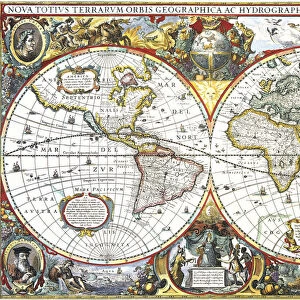
World map in: Tabulae Rudolphinae : quibus astronomicae by Johannes Kepler, 1571-1630

![]()
Wall Art and Photo Gifts from Universal Images Group (UIG)
World map in: Tabulae Rudolphinae : quibus astronomicae by Johannes Kepler, 1571-1630
Universal Images Group (UIG) manages distribution for many leading specialist agencies worldwide
Media ID 20165131
© World History Archive
FEATURES IN THESE COLLECTIONS
> Arts
> Artists
> K
> Johannes Kepler
> Universal Images Group (UIG)
> History
> Historical Maps
EDITORS COMMENTS
This print showcases a remarkable piece of cartographic history - the world map from Johannes Kepler's renowned work, "Tabulae Rudolphinae : quibus astronomicae". Created between 1571 and 1630, this masterpiece by the German astronomer is a testament to his exceptional scientific mind and meticulous attention to detail. The map itself is an exquisite representation of the world during Kepler's time, offering a glimpse into how people perceived our planet centuries ago. With intricate lines and delicate shading, it captures both geographical accuracy and astronomical significance. Each continent is meticulously outlined, while celestial bodies adorn the corners, symbolizing Kepler's profound interest in astronomy. As we gaze upon this extraordinary print from Universal Images Group (UIG), we are transported back in time to an era where exploration was at its peak. It serves as a reminder of humanity's insatiable curiosity about the world beyond our immediate surroundings. Beyond its historical value, this image also holds artistic merit. The harmonious blend of colors and precise craftsmanship make it visually stunning. Whether displayed in a classroom or study space or adorning the walls of an avid collector, this print undoubtedly sparks intellectual curiosity and admiration for both science and art. In preserving such treasures through photography prints like these from UIG, we ensure that future generations can appreciate not only the beauty but also the knowledge encapsulated within these historical artifacts.
MADE IN THE USA
Safe Shipping with 30 Day Money Back Guarantee
FREE PERSONALISATION*
We are proud to offer a range of customisation features including Personalised Captions, Color Filters and Picture Zoom Tools
SECURE PAYMENTS
We happily accept a wide range of payment options so you can pay for the things you need in the way that is most convenient for you
* Options may vary by product and licensing agreement. Zoomed Pictures can be adjusted in the Cart.