Home > Europe > United Kingdom > England > London > Sights > British Museum
French map of Central and South America, showing Florida, Gulf of Mexico, Caribbean Islands

![]()
Wall Art and Photo Gifts from Universal Images Group (UIG)
French map of Central and South America, showing Florida, Gulf of Mexico, Caribbean Islands
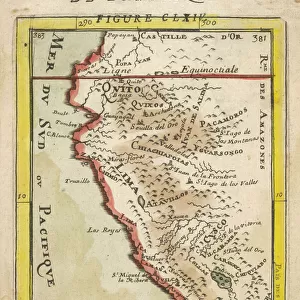
French map of Central and South America, showing Florida, Gulf of Mexico, Caribbean Islands and Antilles, River Plate, Conquistadors in Peru, Cannibals, Gold Mines, Parrots, etc. 1550. British Museum
Universal Images Group (UIG) manages distribution for many leading specialist agencies worldwide
Media ID 9788951
© Universal History Archive/Universal Images Group
1550 America Antilles Caribbean Central Florida Gold Gulf Islands Mexico Mines Museum Parrots Peru Plate River South Cannibals Conquistadors
FEATURES IN THESE COLLECTIONS
> Europe
> United Kingdom
> England
> London
> Sights
> British Museum
> Maps and Charts
> Related Images
> North America
> Mexico
> Maps
> North America
> Mexico
> Related Images
> South America
> Peru
> Maps
> South America
> Peru
> Related Images
> South America
> Related Images
> Universal Images Group (UIG)
> History
> French
EDITORS COMMENTS
This print showcases a remarkable French map of Central and South America from the year 1550. Displayed in the prestigious British Museum, this historical artifact offers a fascinating glimpse into the cartography of that era. The intricate details depicted on this map are truly awe-inspiring. The viewer's attention is immediately drawn to Florida, Gulf of Mexico, Caribbean Islands, and Antilles, which are prominently highlighted. As we explore further, we encounter vivid illustrations depicting various aspects of life during that time period - from Conquistadors in Peru to Cannibals and Gold Mines. Exotic Parrots add a touch of vibrancy to this already mesmerizing artwork. This French map not only serves as an invaluable resource for historians but also ignites our imagination about the explorations and discoveries made by early European settlers in these uncharted territories. It provides us with a window into their perceptions and understanding of the world at that time. As we delve deeper into its intricacies, it becomes evident that this print is more than just a geographical representation; it encapsulates an entire era marked by exploration, conquests, cultural encounters, and natural wonders. With its rich historical significance and stunning visual appeal, this print invites us to embark on a journey through time – allowing us to appreciate both the artistry involved in creating such maps as well as the vastness of knowledge gained over centuries.
MADE IN THE USA
Safe Shipping with 30 Day Money Back Guarantee
FREE PERSONALISATION*
We are proud to offer a range of customisation features including Personalised Captions, Color Filters and Picture Zoom Tools
SECURE PAYMENTS
We happily accept a wide range of payment options so you can pay for the things you need in the way that is most convenient for you
* Options may vary by product and licensing agreement. Zoomed Pictures can be adjusted in the Cart.