Home > Arts > Artists > O > Abraham Ortelius
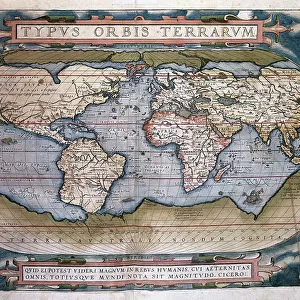
Theatrum Orbis Terrarum by Abraham Ortelius (1527-1598)
")
![]()
Wall Art and Photo Gifts from Mary Evans Picture Library
Theatrum Orbis Terrarum by Abraham Ortelius (1527-1598)
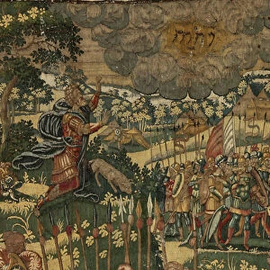
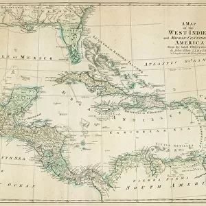
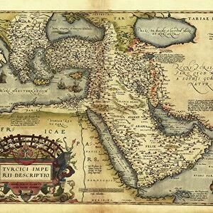
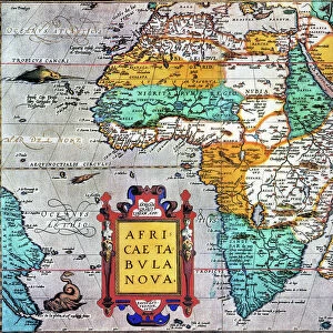
Map of America. Theatrum Orbis Terrarum by Abraham Ortelius (1527-1598). First Edition. Antwerp, 1574
Mary Evans Picture Library makes available wonderful images created for people to enjoy over the centuries
Media ID 14330290
© Thaliastock / Mary Evans
1574 Abraham Americas Antwerp Atlas Barcelona Carthography Cartographic Cartography Catalonia Continent Edition Flanders Flemish Geography Orbis Ortelius Ortels Terrarum Theatrum
FEATURES IN THESE COLLECTIONS
> Arts
> Artists
> O
> Abraham Ortelius
> Arts
> Artists
> O
> Oceanic Oceanic
> Europe
> Belgium
> Related Images
> Maps and Charts
> Abraham Ortelius
EDITORS COMMENTS
This stunning print is a captivating glimpse into the past, showcasing Abraham Ortelius's seminal work, Theatrum Orbis Terrarum, published in Antwerp in 1574. As the first modern atlas, it revolutionized cartography by bringing together a comprehensive collection of maps into a single volume. This particular map, focusing on America, reflects the incomplete yet intriguing understanding of the New World during the 16th century. Ortelius, a Flemish cartographer, created this masterpiece during the Age of Discovery, a time when European explorers were expanding their horizons and uncovering new lands. The map reveals the known continents of North and South America, with various islands scattered throughout the Atlantic Ocean. The detail is remarkable, with depictions of ships sailing the seas, a Spanish vessel anchored off the coast, and a vibrant, colorful representation of the New World. The map's title, Theatrum Orbis Terrarum, translates to 'Theatre of the World,' reflecting the belief that the world was a stage, and the maps within were the actors. This first edition of the atlas was produced in Antwerp, Flanders, and later found its way to Barcelona, Spain, where it is now housed in a prestigious library. The map is a testament to the spirit of exploration and discovery that characterized the 16th century, offering a fascinating glimpse into the historical context of a time when the world was truly a mystery waiting to be unraveled.
MADE IN THE USA
Safe Shipping with 30 Day Money Back Guarantee
FREE PERSONALISATION*
We are proud to offer a range of customisation features including Personalised Captions, Color Filters and Picture Zoom Tools
SECURE PAYMENTS
We happily accept a wide range of payment options so you can pay for the things you need in the way that is most convenient for you
* Options may vary by product and licensing agreement. Zoomed Pictures can be adjusted in the Cart.