Home > Arts > Artists > O > Abraham Ortelius
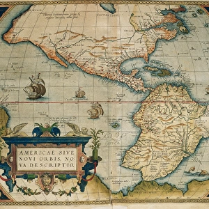
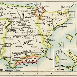
Map of Portugal. Theatrum Orbis Terrarum by Abraham Ortelius

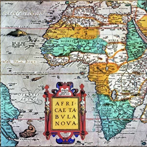
![]()
Wall Art and Photo Gifts from Mary Evans Picture Library
Map of Portugal. Theatrum Orbis Terrarum by Abraham Ortelius
Map of Portugal. Theatrum Orbis Terrarum by Abraham Ortelius (1527-1598). First Edition. Antwerp, 1574. Library of Catalonia. Spain
Mary Evans Picture Library makes available wonderful images created for people to enjoy over the centuries
Media ID 14330961
© Thaliastock / Mary Evans
1574 Abraham Antwerp Atlas Barcelona Cartography Edition Flanders Flemish Geography Iberian Monster Orbis Ortelius Ortels Peninsula Portugal Portuguese Terrarum Theatrum
FEATURES IN THESE COLLECTIONS
> Arts
> Artists
> O
> Abraham Ortelius
> Arts
> Artists
> O
> Oceanic Oceanic
> Europe
> Belgium
> Related Images
> Europe
> Portugal
> Related Images
> Maps and Charts
> Abraham Ortelius
EDITORS COMMENTS
This stunning map print is an exquisite example of cartographic art from the 16th century, specifically the first edition of Abraham Ortelius's seminal work, "Theatrum Orbis Terrarum," published in Antwerp in 1574. The map in question depicts Portugal, a significant European power during this era, with intricate detail and precision. Ortelius (1527-1598), a Flemish cartographer and geographer, is renowned for being the first person to publish a modern, uniform atlas. This map of Portugal is a testament to his groundbreaking work and the advancements in cartography during the Age of Discoveries. The map is held in the prestigious Library of Catalonia in Barcelona, Spain. It showcases the Iberian Peninsula in its entirety, with Portugal occupying a prominent position. The map's coastal features are rendered with remarkable accuracy, revealing the extensive knowledge of the Portuguese maritime explorations during this period. One of the most striking aspects of this map is the inclusion of various monsters and sea creatures along the coasts, reflecting the prevailing beliefs and myths of the time. The presence of a ship in the Atlantic Ocean suggests the importance of maritime trade and exploration. The relief features are depicted with a subtle yet effective use of shading, adding depth and dimension to the map. The intricate detailing of the islands, especially the Azores, further highlights the cartographer's expertise. This map is a fascinating glimpse into the historical geography of Europe during the late 16th century, providing valuable insights into the political, cultural, and exploratory milestones of the time. Its preservation in the Library of Catalonia ensures its continued significance in the study of cartography and European history.
MADE IN THE USA
Safe Shipping with 30 Day Money Back Guarantee
FREE PERSONALISATION*
We are proud to offer a range of customisation features including Personalised Captions, Color Filters and Picture Zoom Tools
SECURE PAYMENTS
We happily accept a wide range of payment options so you can pay for the things you need in the way that is most convenient for you
* Options may vary by product and licensing agreement. Zoomed Pictures can be adjusted in the Cart.