Home > Europe > Spain > Maps
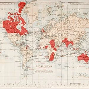
A mid-18th century map of the British Empire in North America also showing French, Spanish and Dutch settlements. After a work by British cartographer Henry Popple, ? - died 1743. This is a later edition of Popples map, published by Covens and Mortier in Amsterdam, circa 1750

![]()
Wall Art and Photo Gifts from Design Pics
A mid-18th century map of the British Empire in North America also showing French, Spanish and Dutch settlements. After a work by British cartographer Henry Popple, ? - died 1743. This is a later edition of Popples map, published by Covens and Mortier in Amsterdam, circa 1750
Design Pics offers Distinctively Different Imagery representing over 1,500 contributors
Media ID 24905853
© Ken Welsh
18th Century Americas Caribbean Cartography Continent Dutch Geographical Geography Lands Maps Settlements Spanish
FEATURES IN THESE COLLECTIONS
> Maps and Charts
> British Empire Maps
> Maps and Charts
> Early Maps
> Maps and Charts
> Related Images
> Maps and Charts
> Spain
EDITORS COMMENTS
This print showcases a mid-18th century map of the British Empire in North America, offering a glimpse into the historical landscape of the continent. Created by renowned British cartographer Henry Popple, this particular edition was published by Covens and Mortier in Amsterdam around 1750. The intricate details on this map reveal not only the vast expanse of the British Empire but also highlight French, Spanish, and Dutch settlements scattered across North America. It serves as a visual representation of the complex geopolitical dynamics that shaped this era. With its rich colors and meticulous illustrations, this map transports viewers back to a time when exploration and colonization were at their peak. The inclusion of various settlements adds depth to our understanding of how different European powers sought to establish their presence in these lands. As an archival piece, this print is more than just an artistic depiction; it is a valuable historical artifact that offers insight into early American history. Its significance lies not only in its geographical accuracy but also in its ability to evoke curiosity about past events and inspire further exploration into our shared heritage. Ken Welsh's expertly captured image preserves both the beauty and historical importance of Popples' work for generations to come. Whether displayed as part of an educational exhibit or admired for personal enjoyment, this print invites us to delve deeper into the fascinating world depicted on its surface.
MADE IN THE USA
Safe Shipping with 30 Day Money Back Guarantee
FREE PERSONALISATION*
We are proud to offer a range of customisation features including Personalised Captions, Color Filters and Picture Zoom Tools
SECURE PAYMENTS
We happily accept a wide range of payment options so you can pay for the things you need in the way that is most convenient for you
* Options may vary by product and licensing agreement. Zoomed Pictures can be adjusted in the Cart.