Home > Historic > Colonial America illustrations > 18th century America
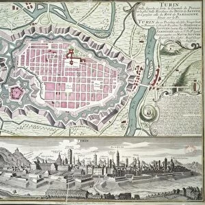
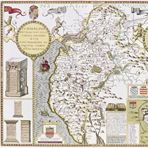
Colonial America: Map of Louisiana, New France (litho)
")
![]()
Wall Art and Photo Gifts from Fine Art Finder
Colonial America: Map of Louisiana, New France (litho)
PNP351123 Colonial America: Map of Louisiana, New France (litho) by French School; Private Collection; (add.info.: from the original map by Jean-Baptiste Bernard de la Harpe (1683-1765); French explorer and cartographer; ); Peter Newark American Pictures; French, out of copyright
Media ID 22678574
© Peter Newark American Pictures / Bridgeman Images
Deep South Mapping Southern States
FEATURES IN THESE COLLECTIONS
> Fine Art Finder
> Artists
> Dutch School
> Fine Art Finder
> Artists
> School French
> Fine Art Finder
> Maps (celestial & Terrestrial)
> Historic
> Colonial America illustrations
> 18th century America
> Historic
> Colonial America illustrations
> Colonial America
> Maps and Charts
> Related Images
> South America
> Related Images
EDITORS COMMENTS
This lithographic print showcases a historical map of Colonial America, specifically Louisiana in New France. The intricate details and vibrant colors bring to life the rich history of this region during the 18th century. The map is a reproduction from the original work by Jean-Baptiste Bernard de la Harpe, a renowned French explorer and cartographer. De la Harpe's expertise in mapping is evident as he meticulously captures the geography and topography of Louisiana, providing valuable insights into this unexplored territory. As we delve into this piece, we are transported back in time to an era when cartography was both an art form and a scientific endeavor. This map serves as a testament to the exploratory spirit that defined colonial America, with its vast landscapes waiting to be discovered. The deep south comes alive through this visual representation, revealing not only geographical features but also cultural influences that shaped Louisiana's identity during this period. It offers us glimpses into settlements, rivers, forests, and other landmarks that were crucial for navigation and trade. Through this litho print from Fine Art Finder's private collection, we can appreciate the beauty of early cartography while gaining insight into how our understanding of geography has evolved over time. This image reminds us of the importance of preserving historical artifacts like maps as they provide invaluable knowledge about our past.
MADE IN THE USA
Safe Shipping with 30 Day Money Back Guarantee
FREE PERSONALISATION*
We are proud to offer a range of customisation features including Personalised Captions, Color Filters and Picture Zoom Tools
FREE COLORIZATION SERVICE
You can choose advanced AI Colorization for this picture at no extra charge!
SECURE PAYMENTS
We happily accept a wide range of payment options so you can pay for the things you need in the way that is most convenient for you
* Options may vary by product and licensing agreement. Zoomed Pictures can be adjusted in the Cart.