Home > Europe > France > Canton > Landes
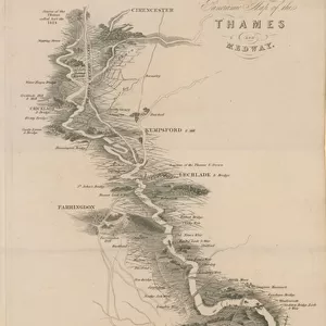
Chart of the Thames and Approaches, Tilbury Dock to North Foreland (litho)
")
![]()
Wall Art and Photo Gifts from Fine Art Finder
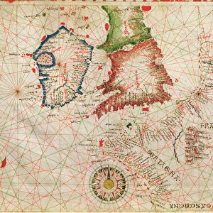
Chart of the Thames and Approaches, Tilbury Dock to North Foreland (litho)
3651382 Chart of the Thames and Approaches, Tilbury Dock to North Foreland (litho) by English School, (19th century); Private Collection; (add.info.: Chart of the Thames and Approaches, Tilbury Dock to North Foreland. Illustration for the Orient Line Guide edited by W J Loftie (3rd edn, Sampson Low, 1889).); © Look and Learn
Media ID 22978468
© Look and Learn / Bridgeman Images
Approaches Chart Globe International Land Orient Line Guide Route Routes Tourists North Foreland
FEATURES IN THESE COLLECTIONS
> Europe
> France
> Canton
> Landes
> Fine Art Finder
> Artists
> English Photographer
> Fine Art Finder
> Artists
> English School
> Maps and Charts
> Related Images
> Maps and Charts
> World
EDITORS COMMENTS
This lithograph, titled "Chart of the Thames and Approaches, Tilbury Dock to North Foreland" takes us back in time to the 19th century. The print showcases a meticulously detailed map that was originally featured in the Orient Line Guide edited by W J Loftie. As we gaze upon this historical artwork, our eyes are drawn to the intricate lines and markings that depict various routes and approaches along the Thames River. This chart served as an essential navigational tool for sailors and travelers alike, guiding them through their journeys across land and sea. The presence of a globe in the foreground reminds us of the vastness of our world and ignites a sense of wanderlust within us. It symbolizes exploration, adventure, and discovery - all elements that were integral to travel during this era. Intriguingly, we also spot tourists scattered around the scene, perhaps marveling at this impressive piece or planning their own expeditions. Their presence highlights how travel has always been deeply ingrained in human nature - an innate desire to explore new horizons. This lithograph not only serves as a visual delight but also offers insight into international tourism during its time. It is a testament to humanity's enduring fascination with maps and charts as tools for understanding our place in the world. With its rich history captured on paper through meticulous engraving techniques, this print from Bridgeman Images invites us on a journey through time while reminding us of our timeless yearning for adventure.
MADE IN THE USA
Safe Shipping with 30 Day Money Back Guarantee
FREE PERSONALISATION*
We are proud to offer a range of customisation features including Personalised Captions, Color Filters and Picture Zoom Tools
SECURE PAYMENTS
We happily accept a wide range of payment options so you can pay for the things you need in the way that is most convenient for you
* Options may vary by product and licensing agreement. Zoomed Pictures can be adjusted in the Cart.