Home > Fine Art Storehouse > The Magical World of Illustration > Nastasic Images & Illustrations
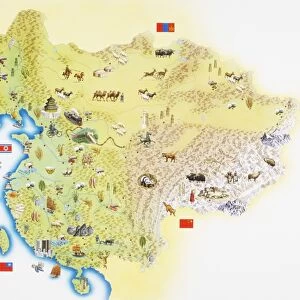
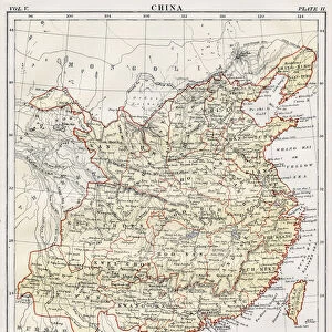
Map of Korea, China

![]()
Wall Art and Photo Gifts from Fine Art Storehouse
Map of Korea, China
Antique illustration of a Map of Korea, China
Unleash your creativity and transform your space into a visual masterpiece!
Nastasic
Media ID 13592081
© Nikola Nastasic
Art Product Backgrounds Black Color Direction Frame Globe Man Made Object Globe Navigational Equipment Korea Latitude Longitude Monoprint Nation National Pencil Drawing Region Residential District Topography World Map China East Asia Drawing Art Product Obsolete Retro Styled White Color
FEATURES IN THESE COLLECTIONS
> Fine Art Storehouse
> The Magical World of Illustration
> Nastasic Images & Illustrations
> Fine Art Storehouse
> Map
> Historical Maps
EDITORS COMMENTS
This antique illustration of a Map of Korea and China takes us on a journey through time. With its retro styling and intricate details, it offers a glimpse into the cartography of yesteryears. The engraved image showcases the obsolete artistry of etching and pencil drawing, evoking a sense of nostalgia for traditional craftsmanship. The monoprint captures the topography of these Asian nations with precision, displaying longitude and latitude lines that guide our exploration. Its black and white color palette adds to its timeless appeal, reminding us of ancient cultures and histories that have shaped this region. Framed as an art product, this print becomes more than just a map; it becomes a piece of physical geography that can adorn any space beautifully. Its background features elements from world maps, emphasizing the interconnectedness between different nations throughout history. As we gaze upon this artwork by Nastasic, we are transported to residential districts in China's East Asia or vibrant cities in Korea. It serves as both an educational tool and an aesthetic delight – inviting us to delve into the rich tapestry woven by these nations' pasts. With no mention made about commercial use or any specific company associated with it, this print stands alone as an exquisite representation of two countries intertwined by their shared borders but distinct in their own unique identities.
MADE IN THE USA
Safe Shipping with 30 Day Money Back Guarantee
FREE PERSONALISATION*
We are proud to offer a range of customisation features including Personalised Captions, Color Filters and Picture Zoom Tools
SECURE PAYMENTS
We happily accept a wide range of payment options so you can pay for the things you need in the way that is most convenient for you
* Options may vary by product and licensing agreement. Zoomed Pictures can be adjusted in the Cart.