Home > North America > United States of America > New York > New York > Maps
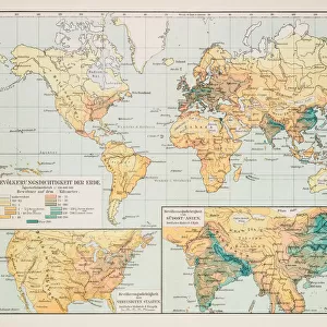
Polar projection of the world map 1856

![]()
Wall Art and Photo Gifts from Fine Art Storehouse
Polar projection of the world map 1856
Colton and Fitchs Modern School Geography by George W. Fitch - New York 1856
Unleash your creativity and transform your space into a visual masterpiece!
THEPALMER
Media ID 13612307
© Roberto A Sanchez
62990 Antarctica Arctic Business Finance And Industry Cartographer Earth East East Asia Equator Line Globe Man Made Object Globe Navigational Equipment Hemisphere North Pole Planet Earth Polar Climate Pole South Pole Space Time Zone Topography World Map Drawing Art Product
FEATURES IN THESE COLLECTIONS
> Asia
> Related Images
> Fine Art Storehouse
> The Magical World of Illustration
> Palmer Illustrated Collection
> Fine Art Storehouse
> Map
> Historical Maps
> Maps and Charts
> Early Maps
> Maps and Charts
> World
> North America
> United States of America
> New York
> New York
> Maps
EDITORS COMMENTS
This print showcases a remarkable piece of cartographic history - the Polar projection of the world map from 1856. Taken from George W. Fitch's renowned "Colton and Fitchs Modern School Geography" this antique illustration transports us back to a time when exploration and discovery were at their peak. The intricately engraved lines depict the topography of our planet, with particular emphasis on the polar regions. The South Pole takes center stage, surrounded by vast expanses of ice that define the polar climate. As we move towards the equator line, we witness a gradual shift in landscapes, revealing continents such as East Asia and Antarctica. Every detail has been meticulously captured in this stunning print - from time zones marking global divisions to the Arctic region's unique characteristics. It serves as a testament to human ingenuity and curiosity about our Earth's physical geography. As we gaze upon this man-made object suspended in space, it reminds us of our place within an ever-changing world. The horizontal composition allows for easy navigation across hemispheres, inviting viewers to explore every corner of our planet through its intricate details. "The Palmer" has masterfully transformed this historical drawing into an art product that captivates both enthusiasts and scholars alike. With its timeless appeal and rich historical significance, this print is truly a treasure worth cherishing for generations to come.
MADE IN THE USA
Safe Shipping with 30 Day Money Back Guarantee
FREE PERSONALISATION*
We are proud to offer a range of customisation features including Personalised Captions, Color Filters and Picture Zoom Tools
SECURE PAYMENTS
We happily accept a wide range of payment options so you can pay for the things you need in the way that is most convenient for you
* Options may vary by product and licensing agreement. Zoomed Pictures can be adjusted in the Cart.