Home > Arts > Artists > W > Charles White
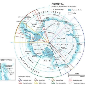
Antarctica map with sea routes of various explorers, lithograph, 1897

![]()
Wall Art and Photo Gifts from Fine Art Storehouse
Antarctica map with sea routes of various explorers, lithograph, 1897
Historical map of the unexplored Antarctica with sea routes of various explorers, 18th - 19th century. Lithograph, published in 1897
Unleash your creativity and transform your space into a visual masterpiece!
ZU_09
Media ID 35843106
18th Century Adventure Antarctica Australia Explorer New Zealand Sea Passage South America South Pole Captain Cook Multi Colored White Color
FEATURES IN THESE COLLECTIONS
> Arts
> Artists
> W
> Charles White
> Fine Art Storehouse
> Map
> Historical Maps
> Maps and Charts
> Early Maps
> Maps and Charts
> Related Images
> Oceania
> Australia
> Related Images
> Oceania
> New Zealand
> Maps
> Oceania
> New Zealand
> Related Images
> South America
> Related Images
EDITORS COMMENTS
This stunning lithograph, published in 1897, offers a captivating glimpse into the unexplored territories of Antarctica during the late 18th and 19th centuries. The map, adorned with a crisp white background, vividly depicts the icy continent with intricate detail, its vast expanses of ice and water shimmering in blues and whites. At the heart of the map lies the elusive South Pole, a blank space of uncharted territory, beckoning the brave and the curious. The map is a testament to the spirit of adventure and exploration that defined this era. It marks the sea routes of some of the most renowned explorers of the time, including Captain James Cook and Charles Wilkes. Cook's explorations in the Pacific Ocean brought him close to Antarctica, but he was unable to reach the continent. Wilkes, on the other hand, led the United States Exploring Expedition to Antarctica in the 1830s and charted significant portions of the Antarctic coastline. The map also reveals the connections between Antarctica and other parts of the world, with sea passages leading from the Atlantic and Indian Oceans to the Southern Ocean that surrounds Antarctica. The map's vertical orientation and multi-colored engraving add to its aesthetic appeal, making it a fascinating historical document that transports us back in time to an era of discovery and exploration.
MADE IN THE USA
Safe Shipping with 30 Day Money Back Guarantee
FREE PERSONALISATION*
We are proud to offer a range of customisation features including Personalised Captions, Color Filters and Picture Zoom Tools
SECURE PAYMENTS
We happily accept a wide range of payment options so you can pay for the things you need in the way that is most convenient for you
* Options may vary by product and licensing agreement. Zoomed Pictures can be adjusted in the Cart.