Home > Europe > Norway > Maps
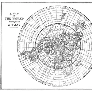
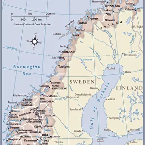
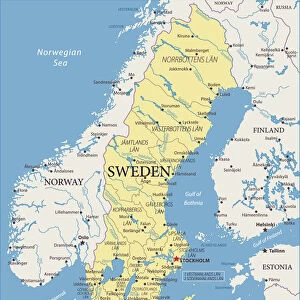
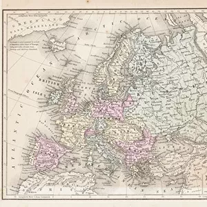
Antique Map of Sweden and Norway

![]()
Wall Art and Photo Gifts from Fine Art Storehouse
Antique Map of Sweden and Norway
Antique map of Sweden and Norway from 1867
Unleash your creativity and transform your space into a visual masterpiece!
duncan1890
Media ID 13666585
© Duncan Walker
Baltic Sea Chart Equipment Navigational Equipment Nordic Countries Northern Europe Norway Past Retro Revival Scandinavia Styles Sweden Image Created 19th Century Obsolete Retro Styled Scandinavian Peninsula Victorian Style
FEATURES IN THESE COLLECTIONS
> Fine Art Storehouse
> Map
> Historical Maps
> Maps and Charts
> Early Maps
EDITORS COMMENTS
This stunning print captures the essence of a bygone era with its Antique Map of Sweden and Norway from 1867. The intricate details and craftsmanship showcased in this cartographic masterpiece transport us back to the 19th century, evoking a sense of nostalgia and wonder. The retro revival style of this print pays homage to the rich history of mapmaking, where engraved images were meticulously crafted to guide explorers across uncharted territories. With its vibrant colors and Victorian flair, it seamlessly blends illustration and painting techniques that were popular during that time period. As we gaze upon this image created over a century ago, we are reminded of the importance placed on navigational equipment such as charts in an age when technology was still in its infancy. The Scandinavian Peninsula comes alive before our eyes, with Sweden and Norway prominently displayed amidst the vastness of Northern Europe's Baltic Sea. This antique map serves as a visual time capsule, transporting us back to an era when these Nordic countries held great significance in European history. It invites us to explore their past through the lens of cartography while appreciating the artistry involved in creating such detailed representations. With no people present within this vertical composition, our focus is solely on admiring the beauty and historical value encapsulated within this retro-styled illustration turned photography. Duncan1890 has masterfully captured not just an image but also a piece of history for all to enjoy.
MADE IN THE USA
Safe Shipping with 30 Day Money Back Guarantee
FREE PERSONALISATION*
We are proud to offer a range of customisation features including Personalised Captions, Color Filters and Picture Zoom Tools
SECURE PAYMENTS
We happily accept a wide range of payment options so you can pay for the things you need in the way that is most convenient for you
* Options may vary by product and licensing agreement. Zoomed Pictures can be adjusted in the Cart.