Home > Arts > Street art graffiti > Digital art > Vector illustrations
Killeen Texas US City Street Map

![]()
Wall Art and Photo Gifts from Fine Art Storehouse
Killeen Texas US City Street Map
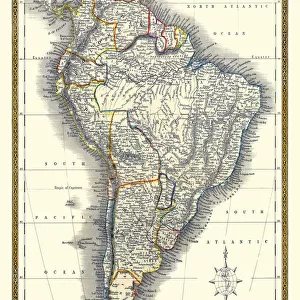
Vector Illustration of a City Street Map of Killeen, Texas, USA. Scale 1:60, 000.
All source data is in the public domain.
U.S. Geological Survey, US Topo
Used Layers:
USGS The National Map: National Hydrography Dataset (NHD)
USGS The National Map: National Transportation Dataset (NTD)
Unleash your creativity and transform your space into a visual masterpiece!
Frank Ramspott
Media ID 15192968
© Frank Ramspott, all rights reserved
Aerial View City Map Computer Graphic Directly Above Downtown District Gray Road Map Texas Text Digitally Generated Image Green Color Killeen White Color
FEATURES IN THESE COLLECTIONS
> Aerial Photography
> Related Images
> Animals
> Insects
> Hemiptera
> Green Scale
> Arts
> Contemporary art
> Digital artwork
> Street art
> Arts
> Landscape paintings
> Waterfall and river artworks
> River artworks
> Arts
> Portraits
> Pop art gallery
> Street art portraits
> Arts
> Street art graffiti
> Digital art
> Digital paintings
> Arts
> Street art graffiti
> Digital art
> Vector illustrations
> Fine Art Storehouse
> Map
> Street Maps
> Fine Art Storehouse
> Map
> USA Maps
> Maps and Charts
> Geological Map
> Maps and Charts
> Related Images
> North America
> United States of America
> Lakes
> Related Images
EDITORS COMMENTS
This print showcases a meticulously detailed city street map of Killeen, Texas, USA. With a scale of 1:60,000, every intricate aspect of this vibrant city is brought to life in stunning vector illustration. The source data used for this masterpiece is all in the public domain and has been derived from reliable sources such as the U. S. Geological Survey and US Topo. The various layers utilized in creating this artwork include the USGS National Hydrography Dataset (NHD) and the National Transportation Dataset (NTD), both contributing to an accurate representation of Killeen's water bodies, transportation routes, downtown district, lake, river systems, streets, roads and more. Designed by Frank Ramspott with exceptional attention to detail and creativity; this digitally generated image offers a unique perspective on Killeen's cartography. The absence of people allows viewers to focus solely on the beauty and complexity of the city's layout. Displayed in color with shades of gray, blue, white and green; this aerial view provides a comprehensive overview that highlights Killeen's physical geography. The inclusion of text enhances navigational understanding while adding an artistic touch to the composition. Perfect for enthusiasts who appreciate fine art or those seeking decorative pieces that celebrate their connection to Killeen, Texas; this print effortlessly combines design expertise with geographic accuracy resulting in a visually striking representation worthy of admiration.
MADE IN THE USA
Safe Shipping with 30 Day Money Back Guarantee
FREE PERSONALISATION*
We are proud to offer a range of customisation features including Personalised Captions, Color Filters and Picture Zoom Tools
SECURE PAYMENTS
We happily accept a wide range of payment options so you can pay for the things you need in the way that is most convenient for you
* Options may vary by product and licensing agreement. Zoomed Pictures can be adjusted in the Cart.