Home > Arts > Street art graffiti > Digital art > Vector illustrations
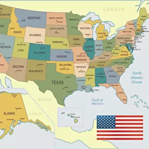
Salinas California US City Street Map

![]()
Wall Art and Photo Gifts from Fine Art Storehouse
Salinas California US City Street Map
Vector Illustration of a City Street Map of Salinas, California, USA. Scale 1:60, 000.
All source data is in the public domain.
U.S. Geological Survey, US Topo
Used Layers:
USGS The National Map: National Hydrography Dataset (NHD)
USGS The National Map: National Transportation Dataset (NTD)
Unleash your creativity and transform your space into a visual masterpiece!
Frank Ramspott
Media ID 15054923
© Frank Ramspott, all rights reserved
Aerial View California City Map Computer Graphic Directly Above Downtown District Gray Road Map Text Digitally Generated Image Green Color Salinas White Color
FEATURES IN THESE COLLECTIONS
> Aerial Photography
> Related Images
> Animals
> Insects
> Hemiptera
> Green Scale
> Animals
> Mammals
> Cricetidae
> California Mouse
> Arts
> Contemporary art
> Digital artwork
> Street art
> Arts
> Landscape paintings
> Waterfall and river artworks
> River artworks
> Arts
> Portraits
> Pop art gallery
> Street art portraits
> Arts
> Street art graffiti
> Digital art
> Digital paintings
> Arts
> Street art graffiti
> Digital art
> Vector illustrations
> Fine Art Storehouse
> Map
> Street Maps
> Fine Art Storehouse
> Map
> USA Maps
> Maps and Charts
> Geological Map
> Maps and Charts
> Related Images
EDITORS COMMENTS
This print showcases a detailed and intricately designed city street map of Salinas, California, USA. With a scale of 1:60,000, this vector illustration offers an accurate representation of the city's downtown district, including its river, lake, streets, and roads. The map is created using various layers sourced from public domain data such as USGS The National Map: National Hydrography Dataset (NHD) and USGS The National Map: National Transportation Dataset (NTD), ensuring reliability and precision. The digitally generated image beautifully combines elements of cartography and design to create a visually stunning aerial view directly above Salinas. Shades of gray, green, blue, and white are strategically used to enhance the clarity and readability of the map. Text is incorporated throughout to label important landmarks and areas. Photographer Frank Ramspott skillfully captures this remarkable piece that serves both as an art form and functional tool for navigation within the city. This print is perfect for those who appreciate fine details in physical geography or anyone with a connection to Salinas looking to adorn their walls with a unique piece that represents their hometown accurately.
MADE IN THE USA
Safe Shipping with 30 Day Money Back Guarantee
FREE PERSONALISATION*
We are proud to offer a range of customisation features including Personalised Captions, Color Filters and Picture Zoom Tools
SECURE PAYMENTS
We happily accept a wide range of payment options so you can pay for the things you need in the way that is most convenient for you
* Options may vary by product and licensing agreement. Zoomed Pictures can be adjusted in the Cart.