Home > Historic > Ancient civilizations > Ancient Greece > Greek history
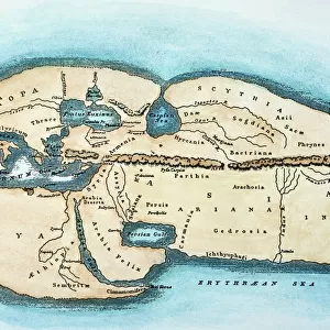
WORLD MAP: ERATOSTHENES. World map based on the conceptions of the ancient Greek geographer Eratosthenes of Cyrene (c276-c194 B. C. ), published at London in 1874. Color line engraving
, published at London in 1874. Color line engraving")
![]()
Wall Art and Photo Gifts from Granger
WORLD MAP: ERATOSTHENES. World map based on the conceptions of the ancient Greek geographer Eratosthenes of Cyrene (c276-c194 B. C. ), published at London in 1874. Color line engraving
WORLD MAP: ERATOSTHENES. World map based on the conceptions of the ancient Greek geographer Eratosthenes of Cyrene (c276-c194 B.C.), published at London in 1874. Color line engraving
Granger holds millions of images spanning more than 25,000 years of world history, from before the Stone Age to the dawn of the Space Age
Media ID 7560803
Geographer Hellenic Republic World Eratosthenes
FEATURES IN THESE COLLECTIONS
> Europe
> Greece
> Related Images
> Historic
> Ancient civilizations
> Ancient Greece
> Greek history
> Maps and Charts
> Early Maps
> Maps and Charts
> Related Images
> Maps and Charts
> World
EDITORS COMMENTS
This print showcases a remarkable piece of history - the "WORLD MAP: ERATOSTHENES". Created in 1874 and based on the conceptions of the ancient Greek geographer Eratosthenes of Cyrene, this color line engraving transports us back to a time when cartography was still in its infancy. The intricate details of this world map are truly awe-inspiring. Every contour and feature has been meticulously etched onto the paper, revealing an expansive view of our planet as seen through the eyes of Eratosthenes over two thousand years ago. From vast oceans to sprawling continents, every corner is brought to life with vibrant colors that add depth and richness. As we explore this ancient depiction, we can't help but marvel at how much our understanding of geography has evolved since then. The river systems are elegantly illustrated, showcasing their importance in connecting different regions across the globe. This map serves as a testament to Eratosthenes' profound knowledge and his contribution towards shaping our perception of the world. Published in London by The Granger Collection, this print allows us to appreciate not only the artistry behind it but also its historical significance. It serves as a reminder that even centuries-old maps continue to hold value today for their ability to transport us into another era and deepen our appreciation for human ingenuity throughout history.
MADE IN THE USA
Safe Shipping with 30 Day Money Back Guarantee
FREE PERSONALISATION*
We are proud to offer a range of customisation features including Personalised Captions, Color Filters and Picture Zoom Tools
SECURE PAYMENTS
We happily accept a wide range of payment options so you can pay for the things you need in the way that is most convenient for you
* Options may vary by product and licensing agreement. Zoomed Pictures can be adjusted in the Cart.