Home > Europe > United Kingdom > England > London > Towns > Hither Green
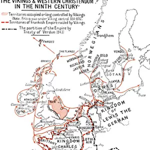
England, Scotland and Ireland - Time of Viking Invasions, 1926. Creators: Unknown

![]()
Wall Art and Photo Gifts from Heritage Images
England, Scotland and Ireland - Time of Viking Invasions, 1926. Creators: Unknown
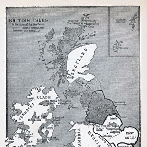
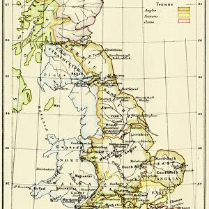
England, Scotland and Ireland - Time of Viking Invasions, 1926. Map of Britain during the 9th-11th century. Towns of Viking foundation in Ireland underlined. Districts settled by Norse or Danes in England and Scotland are underlined. The arrows are the Viking sea routes. From " History of England", by George Macaulay Trevelyan. [Longmans, Green and Co. Ltd, London, 1926]
Heritage Images features heritage image collections
Media ID 19044898
© The Print Collector/Heritage Images
Anglo Saxon Attack Boutall Cartography Celtic Coastline Cockerell Emery Emery Walker Limited Emery Walker Ltd Great Britain Green And Co History Of England Invasion Ireland Longman Longman And Co Longmans Map Making North Sea Occupied Territory Roberts And Green Trevelyan Viking Wales Walker Walker And Walker And Boutall Walker And Cockerell Danish
FEATURES IN THESE COLLECTIONS
> Animals
> Mammals
> Dogs (Domestic)
> Working
> Great Dane
> Arts
> Literature
> Books
> Arts
> Literature
> Arts
> Minimalist artwork
> Monochrome artwork
> Monochrome paintings
> Europe
> Republic of Ireland
> Maps
> Europe
> United Kingdom
> England
> London
> Towns
> Hither Green
> Europe
> United Kingdom
> England
> Maps
> Europe
> United Kingdom
> Scotland
> Maps
> Europe
> United Kingdom
> Wales
> Maps
EDITORS COMMENTS
This print takes us back to the time of Viking invasions in England, Scotland, and Ireland during the 9th-11th century. Created in 1926 by an unknown artist, this map from "History of England" by George Macaulay Trevelyan provides a detailed depiction of Britain's landscape during this tumultuous period. The monochrome image showcases the intricate cartography skills employed to highlight key features such as towns founded by Vikings in Ireland, underlined for emphasis. Similarly, districts settled by Norse or Danes in England and Scotland are also marked with precision. The arrows on the map trace the Viking sea routes that were instrumental in their attacks and occupation of various territories along the coastline. The print beautifully captures both the geographical layout and historical significance of these sea routes. With its rich historical context and meticulous attention to detail, this print serves as a valuable resource for scholars studying Anglo-Saxon history or anyone intrigued by ancient civilizations. It offers a glimpse into a time when these lands were fiercely contested between native Celtic populations and invading Viking forces from Denmark. Preserved through time, this piece is not only an artistic representation but also a testament to our enduring fascination with past events. As we explore this snapshot from nearly a century ago, we are reminded of how history shapes our present-day understanding of culture, identity, and heritage.
MADE IN THE USA
Safe Shipping with 30 Day Money Back Guarantee
FREE PERSONALISATION*
We are proud to offer a range of customisation features including Personalised Captions, Color Filters and Picture Zoom Tools
SECURE PAYMENTS
We happily accept a wide range of payment options so you can pay for the things you need in the way that is most convenient for you
* Options may vary by product and licensing agreement. Zoomed Pictures can be adjusted in the Cart.