Home > Europe > United Kingdom > England > London > Art > Theatre
Map to illustrate the Battle of Messines, First World War, June 1917, (c1920). Creator: Unknown
. Creator: Unknown")
![]()
Wall Art and Photo Gifts from Heritage Images
Map to illustrate the Battle of Messines, First World War, June 1917, (c1920). Creator: Unknown
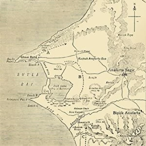
Map to illustrate the Battle of Messines, First World War, June 1917, (c1920). The blue area shows ground gained from the Germans by the British under General Sir Herbert Plumer, 7-14 June 1917. The battle took place on the Western Front near the village of Messines in West Flanders, Belgium. From " The Great World War: A History", Volume VII, edited by Frank A Mumby. [The Gresham Publishing Company Ltd, London, c1920]
Heritage Images features heritage image collections
Media ID 19665907
© The Print Collector/Heritage Images
Baron Plumer Battle Of Messines Battle Of Messines Ridge Field Marshal Plumer Frank A Frank A Mumby Frank Arthur Frank Arthur Mumby Front Line Frontline General Plumer General Sir Herbert Plumer Gresham Publishing Co Ltd Gresham Publishing Company Hco Plumer Herbert Charles Onslow Plumer Herbert Plumer Herbert Plumer 1st Viscount Plumer Keystone Archives Lines Lord Plumer Mumby Mumby Frank A Mumby Frank Arthur Plumer Herbert Plumer Herbert Charles Onslow Position Positions Sir Herbert Plumer Territorial Territory The Great World War A History Theatre Of War Western Front Battlefield Messines
FEATURES IN THESE COLLECTIONS
> Europe
> Belgium
> Related Images
> Europe
> United Kingdom
> England
> London
> Art
> Theatre
> Historic
> Battles
> Related Images
> Historic
> World War I and II
> Battlefields
> Historic
> World War I and II
> Generals and leaders
> Historic
> World War I and II
> World War I
> Historic
> World War I and II
EDITORS COMMENTS
This print showcases a map illustrating the Battle of Messines during the First World War in June 1917. The blue area on the map represents the significant ground gained by British forces, led by General Sir Herbert Plumer, from the Germans between 7th and 14th June 1917. This historic battle took place near the village of Messines in West Flanders, Belgium, on the Western Front. The photograph is sourced from "The Great World War: A History", Volume VII, edited by Frank A Mumby and published around 1920. It provides a vivid visual representation of this crucial moment in history when British troops successfully advanced against German positions. General Sir Herbert Plumer played a pivotal role as commander during this battle and later became known as Baron Plumer and Viscount Plumer for his remarkable leadership skills. The image captures not only an important military event but also highlights Britain's involvement in this global conflict. With its vibrant colors and detailed depiction of territorial lines and positions, this print offers viewers a glimpse into one aspect of the complex theatre of war that defined much of the early twentieth century. It serves as a reminder of those who fought bravely on both sides during these tumultuous times.
MADE IN THE USA
Safe Shipping with 30 Day Money Back Guarantee
FREE PERSONALISATION*
We are proud to offer a range of customisation features including Personalised Captions, Color Filters and Picture Zoom Tools
SECURE PAYMENTS
We happily accept a wide range of payment options so you can pay for the things you need in the way that is most convenient for you
* Options may vary by product and licensing agreement. Zoomed Pictures can be adjusted in the Cart.