Home > Arts > Artists > A > John White Alexander
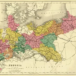
Map illustrating the Russian Invasion of East Prussia, 1915. Creator: Unknown

![]()
Wall Art and Photo Gifts from Heritage Images
Map illustrating the Russian Invasion of East Prussia, 1915. Creator: Unknown
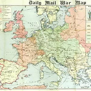
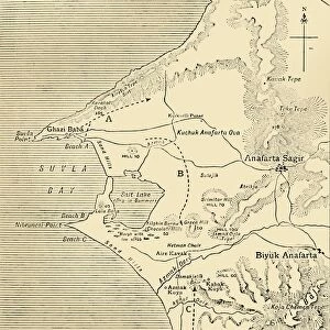
Map illustrating the Russian Invasion of East Prussia, 1915. From August to September 1914, the Russian Empire invaded Germany on the Eastern Front. From " The War Illustrated Album De Luxe - Volume I. The First Phase", edited by J. A. Hammerton. [The Amalgamated Press, Limited, London, 1915]
Heritage Images features heritage image collections
Media ID 19661329
© The Print Collector/Heritage Images
Album Amalgamated Press Amalgamated Press Limited Amalgamated Press Ltd Arrow Baltic Sea Diagram Direction East Prussia First Phase Front Line Frontline Hammerton Hammerton J A Hammerton Ja Hammerton Sir John Alexander Invasion J A Hammerton Ja Hammerton John Hammerton Sir John Alexander Sir John Alexander Hammerton Sir John Hammerton Strategic Strategy The Amalgamated Press The War Illustrated Battlefield
FEATURES IN THESE COLLECTIONS
> Animals
> Mammals
> Cats (Domestic)
> Russian White
> Arts
> Artists
> A
> John White Alexander
> Arts
> Artists
> W
> John White
> Europe
> Russia
> Related Images
> Historic
> World War I and II
> Battlefields
> Historic
> World War I and II
> World War I
> Historic
> World War I and II
EDITORS COMMENTS
This print showcases a historical map illustrating the Russian Invasion of East Prussia in 1915. The creator of this remarkable piece remains unknown, but its significance is undeniable. Taken from "The War Illustrated Album De Luxe - Volume I", edited by J. A. Hammerton and published by The Amalgamated Press Limited in London, this image provides a glimpse into the tumultuous events that unfolded during World War I. During August to September 1914, the Russian Empire launched an invasion on Germany's Eastern Front, making their way into East Prussia. This strategic move altered the course of the war and had far-reaching consequences for both sides involved. The map itself is meticulously detailed, highlighting geographical features such as the Baltic Sea and various locations within East Prussia. It serves as a visual representation of military strategy and direction during this critical phase of World War I. As we observe this historic artifact, it becomes apparent that it holds immense value not only as a record of past events but also as a testament to human resilience amidst conflict. Its presence reminds us of the sacrifices made by countless individuals who fought bravely on these battlefields. Through this photo print, we are transported back in time to witness an important chapter in our shared history – one that shaped nations and defined generations.
MADE IN THE USA
Safe Shipping with 30 Day Money Back Guarantee
FREE PERSONALISATION*
We are proud to offer a range of customisation features including Personalised Captions, Color Filters and Picture Zoom Tools
SECURE PAYMENTS
We happily accept a wide range of payment options so you can pay for the things you need in the way that is most convenient for you
* Options may vary by product and licensing agreement. Zoomed Pictures can be adjusted in the Cart.