Home > Universal Images Group (UIG) > History > Historical Maps
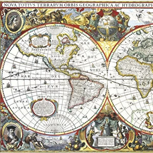
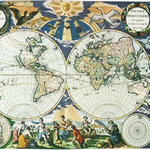
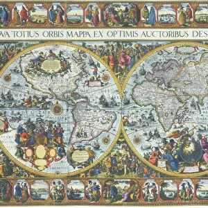
The World. Map of the World 1700, Zumer, A.F

![]()
Wall Art and Photo Gifts from Universal Images Group (UIG)
The World. Map of the World 1700, Zumer, A.F
Universal Images Group (UIG) manages distribution for many leading specialist agencies worldwide
Media ID 20165323
1700 Antiquarian Antiquarian Maps Borders Display Earth Globe Journey Journeys Local Maps Poles Show Small Smaller Spheres Travels Treks Trip Trips Voyage Voyages World Circles Meteorological Phenomena
EDITORS COMMENTS
This print showcases "The World (Map of the World 1700, Zumer, A. F)" - a true masterpiece from the antiquarian era. Created in 1700, this antique map takes us back in time to explore the world as it was known centuries ago. The intricate details and craftsmanship are evident as we observe the carefully drawn borders and circles that delineate countries and regions. As we delve into this mesmerizing display of cartography, we witness an array of meteorological phenomena depicted on the map. From poles to local weather patterns, every element is meticulously illustrated to provide a comprehensive understanding of our planet's diverse climatic conditions. The smaller spheres scattered across the map represent various journeys and voyages undertaken by explorers during that period. These treks symbolize mankind's insatiable thirst for knowledge and adventure as they embarked on daring expeditions to unravel uncharted territories. "The World" serves not only as a historical artifact but also as a testament to human curiosity about our surroundings. It invites us on an imaginary voyage through time, allowing us to appreciate how perceptions of geography have evolved over centuries. This print from Universal Images Group (UIG) captures the essence of exploration and discovery inherent in ancient maps like "The World". Its presence adds depth and intrigue to any space while reminding us of our collective journey throughout history.
MADE IN THE USA
Safe Shipping with 30 Day Money Back Guarantee
FREE PERSONALISATION*
We are proud to offer a range of customisation features including Personalised Captions, Color Filters and Picture Zoom Tools
SECURE PAYMENTS
We happily accept a wide range of payment options so you can pay for the things you need in the way that is most convenient for you
* Options may vary by product and licensing agreement. Zoomed Pictures can be adjusted in the Cart.