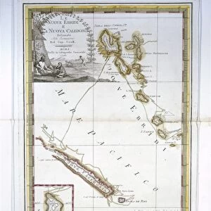
1777, Cook Map of the Friendly Islands or Tonga, topography, cartography, geography

![]()
Wall Art and Photo Gifts from Liszt Collection
1777, Cook Map of the Friendly Islands or Tonga, topography, cartography, geography
1777, Cook Map of the Friendly Islands or Tonga
Liszt Collection of nineteenth-century engravings and images to browse and enjoy
Media ID 14006754
© Artokoloro Quint Lox Limited
1777 Antique Map Latitude Longitude Mappa Mundi Old Antique Plan Old Antique View Ols Antique Map Rare Old Maps Topo
EDITORS COMMENTS
This print showcases the remarkable 1777 Cook Map of the Friendly Islands or Tonga, a true masterpiece in topography, cartography, and geography. With its intricate details and precise measurements, this vintage map takes us on a journey through time to explore the enchanting lands of Tonga. The artistry behind this ancient map is evident in its meticulous depiction of landforms and geographic features. Every contour and curve has been carefully illustrated, allowing us to visualize the diverse topography of these islands with astonishing accuracy. As we gaze upon this historic piece, we are transported back to an era when navigation relied on charts like these. The grid lines marking latitude and longitude create a geometric harmony that aids in understanding distances between different regions. This old antique view not only serves as a window into our past but also ignites our sense of adventure and discovery. It reminds us of the brave explorers who ventured into uncharted territories for scientific knowledge and cultural exchange. With its decorative elements and aged appearance, this rare old map adds an air of sophistication to any space it graces. Whether you are an avid history enthusiast or simply appreciate fine art, this fascinating print from Liszt Collection will surely captivate your imagination while honoring centuries-old cartographic traditions.
MADE IN THE USA
Safe Shipping with 30 Day Money Back Guarantee
FREE PERSONALISATION*
We are proud to offer a range of customisation features including Personalised Captions, Color Filters and Picture Zoom Tools
SECURE PAYMENTS
We happily accept a wide range of payment options so you can pay for the things you need in the way that is most convenient for you
* Options may vary by product and licensing agreement. Zoomed Pictures can be adjusted in the Cart.