Home > Europe > United Kingdom > England > London > Boroughs > Bromley
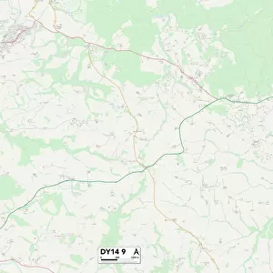
Dudley DY5 4 Map

![]()
Wall Art and Photo Gifts from Map Marketing
Dudley DY5 4 Map
Postcode Sector Map of Dudley DY5 4
Media ID 19969531
Albert Street Avon Close Bell Street Belmont Road Blackwater Close Bradley Street Broad Street Bromley Byron Street Chapel Street Chase Road Church Street Commonside Dell Road Derwent Close Dudley Hamble Close High Street Mayflower Drive Medway Close Milton Street Oakdale Close Queen Street Russett Way School Street Severn Drive Skylark Close Smithy Lane Swan Street Tennyson Street Thames Close The Nook The Plantation Vicarage Lane Victoria Street Weaver Close Wesley Road Woodfield Avenue
FEATURES IN THESE COLLECTIONS
> Animals
> Birds
> Passerines
> Larks
> Skylark
> Animals
> Birds
> Passerines
> Weavers
> Related Images
> Animals
> Birds
> Waterfowl
> Swans
> Related Images
> Arts
> Art Movements
> Art Nouveau
> Arts
> Artists
> B
> Milton Bradley
> Arts
> Artists
> Q
> Queen Victoria Queen Victoria
> Europe
> United Kingdom
> England
> Avon
> Europe
> United Kingdom
> England
> London
> Boroughs
> Bromley
> Map Marketing
> Postcode Sector Maps
> DY - Dudley
MADE IN THE USA
Safe Shipping with 30 Day Money Back Guarantee
FREE PERSONALISATION*
We are proud to offer a range of customisation features including Personalised Captions, Color Filters and Picture Zoom Tools
SECURE PAYMENTS
We happily accept a wide range of payment options so you can pay for the things you need in the way that is most convenient for you
* Options may vary by product and licensing agreement. Zoomed Pictures can be adjusted in the Cart.