Home > Europe > United Kingdom > Scotland > Fife > Crail
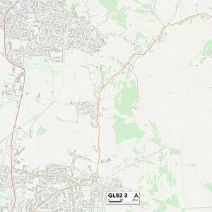
Tewkesbury GL54 3 Map

![]()
Wall Art and Photo Gifts from Map Marketing
Tewkesbury GL54 3 Map
Postcode Sector Map of Tewkesbury GL54 3
Media ID 19970675
A429 Ashdale Close Bassett Road Bradley Drive Bridle Close Brook Close Chapel Lane Church Walk Dale Street Doctors Lane East End Hammond Drive High Street Market Place Mill End Mill View Old Gloucester Road Shepherds Way Tannery Lane Tewkesbury The Green Ward Road West End Chequers Eastington Farmington Naunton Northleach Sherborne Stowell
FEATURES IN THESE COLLECTIONS
> Europe
> United Kingdom
> Scotland
> Fife
> Crail
> Map Marketing
> Postcode Sector Maps
> GL - Gloucester
> Maps and Charts
> Related Images
MADE IN THE USA
Safe Shipping with 30 Day Money Back Guarantee
FREE PERSONALISATION*
We are proud to offer a range of customisation features including Personalised Captions, Color Filters and Picture Zoom Tools
SECURE PAYMENTS
We happily accept a wide range of payment options so you can pay for the things you need in the way that is most convenient for you
* Options may vary by product and licensing agreement. Zoomed Pictures can be adjusted in the Cart.