Home > Europe > United Kingdom > England > Herefordshire > Maps
Plymouth PL5 4 Map

![]()
Wall Art and Photo Gifts from Map Marketing
Plymouth PL5 4 Map
Postcode Sector Map of Plymouth PL5 4
Media ID 19977470
Ashleigh Close Bodmin Road Camborne Close Canterbury Drive Carlisle Road Cunningham Road Derby Road Dorchester Avenue Fore Street Fraser Place Fraser Road Gresham Close Guildford Close Harvest Close Harwood Avenue Henley Drive Hereford Road Lake View Close Lambert Road Lancaster Gardens Linton Close Linton Road Newbury Close Norwich Avenue Nursery Close Oakham Road Plymouth Redruth Close Riverside Walk Rock Hill Saddlers Way Shrewsbury Road Squirrel Close Station Road Taunton Avenue Thompson Road Truro Drive Warren Lane Warwick Avenue Westbury Close Winchester Gardens Milford Lane
FEATURES IN THESE COLLECTIONS
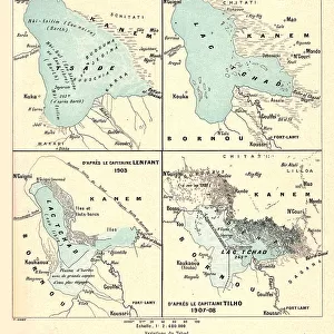
> Africa
> Chad
> Lakes
> Lake Chad
> Africa
> Chad
> Lakes
> Related Images
> Africa
> Chad
> Related Images
> Animals
> Mammals
> Sciuridae
> Rock Squirrel
> Animals
> Mammals
> Squirrel
> Arts
> Artists
> P
> Linton Park
> Europe
> United Kingdom
> England
> Herefordshire
> Maps
> Europe
> United Kingdom
> Northern Ireland
> County Down
> Newcastle
> Europe
> United Kingdom
> Wales
> Monmouthshire
> Monmouth
> Map Marketing
> Postcode Sector Maps
> PL - Plymouth
> Maps and Charts
> Related Images
MADE IN THE USA
Safe Shipping with 30 Day Money Back Guarantee
FREE PERSONALISATION*
We are proud to offer a range of customisation features including Personalised Captions, Color Filters and Picture Zoom Tools
SECURE PAYMENTS
We happily accept a wide range of payment options so you can pay for the things you need in the way that is most convenient for you
* Options may vary by product and licensing agreement. Zoomed Pictures can be adjusted in the Cart.