Home > Arts > Artists > S > John Speed
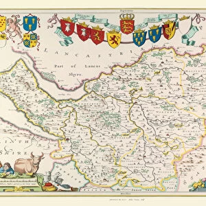
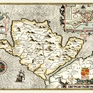
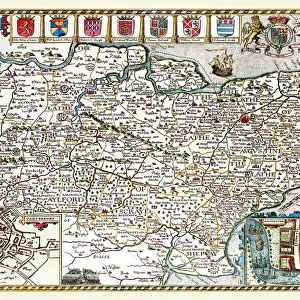
Old County Map of Cheshire 1611 by John Speed

![]()
Wall Art and Photo Gifts from MapSeeker
Old County Map of Cheshire 1611 by John Speed
A facimile of John Speeds historical map of Cheshire originally published for the " Theatre of the Empire of Great Britain", an atlas to accompany " a history of Great Britain"
Welcome to the Mapseeker Image library and enter an historic gateway to one of the largest on-line collections of Historic Maps, Nostalgic Views, Vista's and Panorama's from a World gone by.
Media ID 20347804
© Mapseeker Publishing Ltd
County Map County Map Of England English County Map Historic Map John Speed Map Old County Map Old English County Map Speed Map Speede Map Cheshire
FEATURES IN THESE COLLECTIONS
> Arts
> Artists
> S
> John Speed
> Europe
> United Kingdom
> England
> Cheshire
> Related Images
> Europe
> United Kingdom
> England
> Maps
> Maps and Charts
> British Empire Maps
> Maps and Charts
> Early Maps
> Maps and Charts
> Related Images
> MapSeeker
> Maps from the British Isles
> England and Counties PORTFOLIO
EDITORS COMMENTS
This print showcases the intricate details of the "Old County Map of Cheshire 1611" by John Speed. A true gem from history, this facsimile of Speed's original map was published for his renowned work, "The Theatre of the Empire of Great Britain" an atlas that accompanied a comprehensive history of Great Britain. Transporting us back in time to the early 17th century, this English county map offers a fascinating glimpse into Cheshire's past. Every line and curve on this meticulously crafted cartographic masterpiece tells a story about the region's rich heritage and geographical features. John Speed, an esteemed cartographer and historian, poured his expertise into creating this historical treasure. The attention to detail is evident as you explore every corner of Cheshire through its towns, villages, rivers, forests, and landmarks depicted with remarkable precision. As we delve deeper into this old county map's intricacies, it becomes clear that it serves not only as a navigational tool but also as a window into England's cultural tapestry during that era. It invites us to imagine how life unfolded in these ancient landscapes centuries ago. Whether you are an avid collector or simply captivated by history and geography alike, this stunning print will undoubtedly be cherished for years to come. Let your imagination wander as you immerse yourself in the enchanting world captured within John Speed's historic map – truly a testament to his enduring legacy.
MADE IN THE USA
Safe Shipping with 30 Day Money Back Guarantee
FREE PERSONALISATION*
We are proud to offer a range of customisation features including Personalised Captions, Color Filters and Picture Zoom Tools
SECURE PAYMENTS
We happily accept a wide range of payment options so you can pay for the things you need in the way that is most convenient for you
* Options may vary by product and licensing agreement. Zoomed Pictures can be adjusted in the Cart.