Home > Maps and Charts > Early Maps
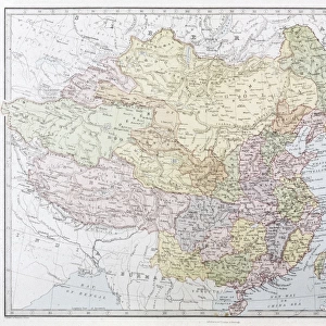
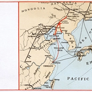
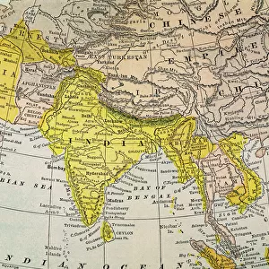
MAP / ASIA C1877

![]()
Wall Art and Photo Gifts from Mary Evans Picture Library
MAP / ASIA C1877
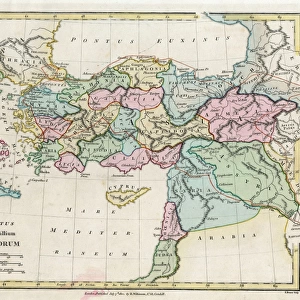
Map of Asia
Mary Evans Picture Library makes available wonderful images created for people to enjoy over the centuries
Media ID 608841
© Mary Evans Picture Library 2015 - https://copyrighthub.org/s0/hub1/creation/maryevans/MaryEvansPictureID/10114143
FEATURES IN THESE COLLECTIONS
> Asia
> Related Images
> Maps and Charts
> Early Maps
> Maps and Charts
> Related Images
EDITORS COMMENTS
Map of Asia, 1877 (C1877) Description: This historical map print, titled "Map of Asia," dates back to the year 1877 and provides an intriguing glimpse into the geographical knowledge of Asia during that era. The map, which is circa 1877, offers a detailed representation of the Asian continent as it was known at the time. The map is rich in information, depicting the various political boundaries, territories, and geographical features of Asia. The borders of major empires and kingdoms, such as the British Raj, the Russian Empire, the Ottoman Empire, and the Qing Dynasty, are clearly marked. The map also shows the location of major cities, rivers, mountains, and other topographical features. The intricate detail of this map is a testament to the advanced cartographic techniques of the late 19th century. The use of color-coding to distinguish different territories and the inclusion of inset maps of specific regions further enhances the map's utility and accuracy. Historically, this map offers valuable insights into the political and geographical landscape of Asia during the late 19th century, a period marked by intense colonial expansion and the scramble for territories. It provides a fascinating perspective on how Asia was perceived and represented during this time and serves as a reminder of the rich history and diversity of the Asian continent. This map print, which is part of the extensive collection of historical maps at Mary Evans Picture Library, is an essential resource for historians, geographers, and anyone interested in the history of Asia or cartography. Its intricate detail and historical significance make it a valuable addition to any collection or research project.
MADE IN THE USA
Safe Shipping with 30 Day Money Back Guarantee
FREE PERSONALISATION*
We are proud to offer a range of customisation features including Personalised Captions, Color Filters and Picture Zoom Tools
SECURE PAYMENTS
We happily accept a wide range of payment options so you can pay for the things you need in the way that is most convenient for you
* Options may vary by product and licensing agreement. Zoomed Pictures can be adjusted in the Cart.