Home > Mary Evans Prints Online > New Images August 2021
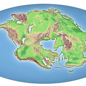
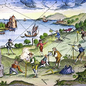
Map of the continents and seas in the Upper Jurassic era

![]()
Wall Art and Photo Gifts from Mary Evans Picture Library
Map of the continents and seas in the Upper Jurassic era
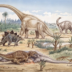
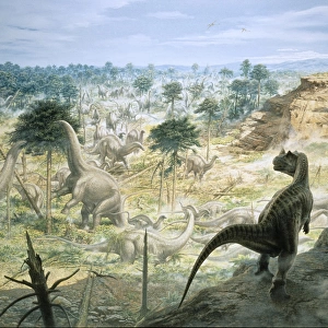
Map of the continents and seas in the Upper Jurassic era. Atlantis, North America, South America, Africa, Europe, Indonesian Peninsula, Asia and Australia. Tethys Ocean, Shetland Strait, Colour print after an illustration from Wilhelm Bolsches Das Leben der Urwelt, Prehistoric Life, Georg Dollheimer, Leipzig, 1932
Mary Evans Picture Library makes available wonderful images created for people to enjoy over the centuries
Media ID 23381578
© Florilegius
Bolsche Brontosaurus Continents Creature Dinosaur Dinosaurs Extinct Freshwater Giant Hugo Jurassic Leben Maage Paleontology Prehistoric Prehistory Seas Urwelt Wilhelm Wolff Upper
FEATURES IN THESE COLLECTIONS
> Africa
> Related Images
> Africa
> South Africa
> Lakes
> Related Images
> Africa
> South Africa
> Maps
> Africa
> South Africa
> Related Images
> Animals
> Extinct
> Dinosaurs
> Arts
> Artists
> O
> Oceanic Oceanic
> Asia
> Indonesia
> Lakes
> Related Images
> Asia
> Indonesia
> Related Images
> Asia
> Related Images
> Mary Evans Prints Online
> New Images August 2021
EDITORS COMMENTS
In this color print from the early 20th century, we are transported back in time to the Upper Jurassic era, approximately 155 to 150 million years ago. This intricately detailed map illustrates the continents and seas that dominated our planet during this epoch, a time when the world looked vastly different from the one we know today. At the heart of the map, we see the supercontinent Pangaea beginning to fragment, with North America and South America starting to separate from each other. Africa, Europe, and Asia are also distinct landmasses, while Australia and the Indonesian Peninsula are still connected to Asia. The vast Tethys Ocean, which would later give birth to the Mediterranean and the Indian Ocean, stretches across the center of the map. Amidst the continents and oceans, we can imagine the giants of the prehistoric world roaming and swimming. Dinosaurs like Brontosaurus, with their long necks and massive bodies, might have wandered through the lush forests and grasslands of the continents. In the freshwater lakes, marine creatures like the elasmosaur, a long-necked, extinct reptile, could have thrived. This map is an exquisite illustration from Wilhelm Bolsche's "Das Leben der Urwelt" (Prehistoric Life), published in Leipzig, Germany, in 1932. The map was created by Hugo Wolff, Maage, and W. Bolsche, and its vibrant colors and intricate detail provide a fascinating glimpse into the world of the Upper Jurassic era. This map is a testament to the rich history of zoology, paleontology, and prehistory, and serves as a reminder of the ever-changing landscape of our planet.
MADE IN THE USA
Safe Shipping with 30 Day Money Back Guarantee
FREE PERSONALISATION*
We are proud to offer a range of customisation features including Personalised Captions, Color Filters and Picture Zoom Tools
SECURE PAYMENTS
We happily accept a wide range of payment options so you can pay for the things you need in the way that is most convenient for you
* Options may vary by product and licensing agreement. Zoomed Pictures can be adjusted in the Cart.