Home > Europe > Italy > Lazio > Rome
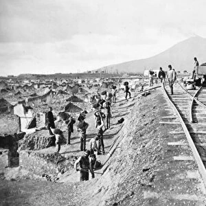
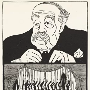
Map of the excavations of Pompeii, 1874-1881

![]()
Wall Art and Photo Gifts from Mary Evans Picture Library
Map of the excavations of Pompeii, 1874-1881
Map of the excavations of Pompeii, showing the Insulae excavated between 1874-1881 in red. Chromolithograph by J.G. Bach after an illustration by Emile Presuhn from his Les Plus Belles Peintures de Pompei (The Most Beautiful Paintings of Pompeii), Leipzig, 1881
Mary Evans Picture Library makes available wonderful images created for people to enjoy over the centuries
Media ID 23198828
© Florilegius/Mary Evans
Bach Beautiful Belles Chart Civilization Emile Excavation Most Mural Paintings Peintures Plan Plus Pompei Pompeii Presuhn Insulae
FEATURES IN THESE COLLECTIONS
> Arts
> Artists
> R
> Roman Roman
> Europe
> Italy
> Lazio
> Rome
> Maps and Charts
> Related Images
> Mary Evans Prints Online
> New Images August 2021
EDITORS COMMENTS
This stunning chromolithograph, created by J.G. Bach based on an illustration by Emile Presuhn in 1881, showcases the intricate and extensive excavations of Pompeii between 1874 and 1881. The vibrant red hues highlight the Insulae, or city blocks, that were unearthed during this period. The map provides a detailed and captivating view of the Roman town frozen in time after the devastating eruption of Mount Vesuvius in AD 79. The Insulae, depicted in the map, were meticulously excavated to reveal the remnants of the ancient Roman civilization. Streets, houses, shops, and public buildings were uncovered, revealing intricate mosaics, frescoes, and other artworks that showcased the wealth and sophistication of the Roman people. This map is an essential record of the archaeological discoveries made in Pompeii during this time. It provides a unique glimpse into the layout of the town, allowing us to visualize the streets and buildings that once bustled with life over 2,000 years ago. The map also serves as a testament to the tireless efforts of archaeologists and historians who have dedicated their lives to uncovering and preserving the rich history of Pompeii and the Roman civilization. Emile Presuhn's illustration, which served as the basis for this map, was originally published in his book "Les Plus Belles Peintures de Pompei" (The Most Beautiful Paintings of Pompeii), which showcased the stunning art and architecture discovered during the excavations. This map is not only a valuable historical document but also a beautiful work of art that captures the essence of Pompeii and the Roman civilization.
MADE IN THE USA
Safe Shipping with 30 Day Money Back Guarantee
FREE PERSONALISATION*
We are proud to offer a range of customisation features including Personalised Captions, Color Filters and Picture Zoom Tools
SECURE PAYMENTS
We happily accept a wide range of payment options so you can pay for the things you need in the way that is most convenient for you
* Options may vary by product and licensing agreement. Zoomed Pictures can be adjusted in the Cart.