Home > Animals > Mammals > Spalacidae > Antiquus
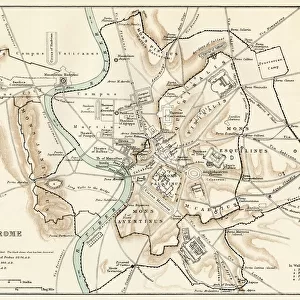
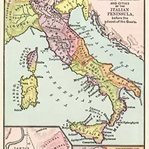
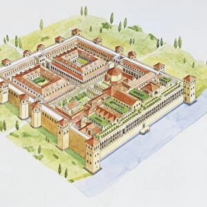
Map of Rome - ancient and modern topography

![]()
Wall Art and Photo Gifts from Mary Evans Picture Library
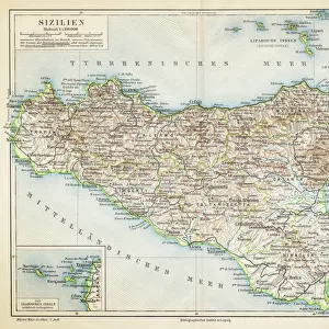
Map of Rome - ancient and modern topography
Map of Rome showing ancient and modern topography. Allegorical figure of Rome. Urbis Topographia ejusque Ambitus Antiquus et Hodiernus. From a map by Francesco Gandini
Mary Evans Picture Library makes available wonderful images created for people to enjoy over the centuries
Media ID 23383286
© Mary Evans Picture Library 2021
Antico Corsi Crypt Ferrario Giulio Grotta Moderno Naples Neapolitan Peoples Pozzuoli Topography Tunnel Posilippo
FEATURES IN THESE COLLECTIONS
> Animals
> Mammals
> Spalacidae
> Antiquus
> Architecture
> Tunnels
> Arts
> Artists
> F
> Giulio Ferrario
> Europe
> Italy
> Campania
> Naples
> Europe
> Italy
> Campania
> Pozzuoli
> Europe
> Italy
> Lazio
> Rome
> Maps and Charts
> Early Maps
> Mary Evans Prints Online
> New Images August 2021
EDITORS COMMENTS
This stunning map print, titled "Urbis Topographia ejusque Ambitus Antiquus et Hodiernus" or "The Topography and Borders of the Ancient and Modern City," is an exquisite example of cartographic art from the Neapolitan school of the 18th century. The map, created by Francesco Gandini and hand-colored, showcases the topography of Rome, both ancient and modern. The allegorical figure of Rome, depicted in the center, proudly holds a shield emblazoned with the image of the city, while the map itself reveals a rich tapestry of history and geography. The map reveals the ancient Roman roads and tunnels, such as the Appian Way and the Tunnel of Domiziana, which still exist today, intertwined with the modern cityscape. Notable landmarks, including the Colosseum, Pantheon, and the Vatican, are clearly marked, as are more recent additions, such as the crypta Neapolitana and the Grotta di Posilippo. The map also highlights the fashion and costumes of the people of the time, adding a vibrant and colorful dimension to the historical representation. The illustration also features various scenes of daily life, showcasing the diverse population of Rome and its surroundings. The map was produced using a copperplate engraving technique, which allowed for intricate detail and precision. The hand-coloring adds a layer of depth and richness, making this map a valuable historical and artistic treasure. This map offers a unique perspective on the history and evolution of Rome, revealing the enduring legacy of the ancient city and its modern-day counterpart. The map also serves as a reminder of the importance of preserving historical records and the role they play in shaping our understanding of the world and its past.
MADE IN THE USA
Safe Shipping with 30 Day Money Back Guarantee
FREE PERSONALISATION*
We are proud to offer a range of customisation features including Personalised Captions, Color Filters and Picture Zoom Tools
SECURE PAYMENTS
We happily accept a wide range of payment options so you can pay for the things you need in the way that is most convenient for you
* Options may vary by product and licensing agreement. Zoomed Pictures can be adjusted in the Cart.