Home > Science > Space Exploration > Planets > Mars
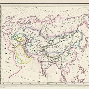
Mars map from 1881

![]()
Wall Art and Photo Gifts from Science Photo Library
Mars map from 1881
Map of Mars, published in Paris in 1881. The first accurate telescope observations of Mars were made in 1877 and 1881 when Mars was at its closest to Earth (a situation called an opposition). The map (north at bottom) does show the dark and light areas thought to be seas and continents, but now known to be highlands (dark) and lowlands (light). The map features are named for famous astronomers. The Mer Sciaparelli (upper right) is now known as Valles Marineris, and Terre de Secchi (upper left) is an impact basin now named Hellas Planitia
Science Photo Library features Science and Medical images including photos and illustrations
Media ID 6431317
© DETLEV VAN RAVENSWAAY/SCIENCE PHOTO LIBRARY
1881 Astronomers Cartography Circular Continents French Hemisphere Hemispheres Highlands History Of Science Impact Crater Lowlands Mars Martian Nineteenth Planetary Projection Seas Solar System Telescope Universe Valles Marineris Cartographical Hellas Planitia
FEATURES IN THESE COLLECTIONS
> Europe
> France
> Paris
> Maps
> Europe
> France
> Paris
> Related Images
> Europe
> United Kingdom
> Scotland
> Highlands
> Related Images
> Maps and Charts
> Early Maps
> Maps and Charts
> Related Images
> Science
> Space Exploration
> Planets
> Earth
> Science
> Space Exploration
> Planets
> Mars
> Science
> Space Exploration
> Solar System
EDITORS COMMENTS
This print showcases a remarkable piece of history: the Mars map from 1881. Published in Paris during a time when telescope observations of Mars were becoming more accurate, this map represents a significant milestone in our understanding of the Red Planet. Taken during an opposition, when Mars was closest to Earth, the map reveals dark and light areas that were initially believed to be seas and continents but are now known as highlands and lowlands respectively. What makes this map even more intriguing is its connection to renowned astronomers. The Mer Sciaparelli, located in the upper right corner of the map, is today recognized as Valles Marineris - one of the largest canyons in our solar system. Similarly, Terre de Secchi (upper left) has been identified as Hellas Planitia - an impact basin on Mars. The intricate details captured on this 19th-century French projection provide us with valuable insights into early Martian cartography. It serves as a testament to humanity's relentless pursuit of knowledge about distant worlds beyond our own. As we gaze upon this mesmerizing image, we are reminded of how far we have come in unraveling the mysteries hidden within our universe. This print from Science Photo Library not only offers us a glimpse into scientific history but also ignites curiosity about what lies ahead for future explorations on Mars and beyond.
MADE IN THE USA
Safe Shipping with 30 Day Money Back Guarantee
FREE PERSONALISATION*
We are proud to offer a range of customisation features including Personalised Captions, Color Filters and Picture Zoom Tools
SECURE PAYMENTS
We happily accept a wide range of payment options so you can pay for the things you need in the way that is most convenient for you
* Options may vary by product and licensing agreement. Zoomed Pictures can be adjusted in the Cart.