Home > Arts > Artists > O > Oceanic Oceanic
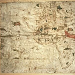
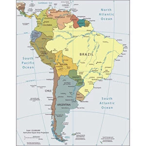
Map of Africa and South America by Domingo Sanchez, 1618

![]()
Wall Art and Photo Gifts from Universal Images Group (UIG)
Map of Africa and South America by Domingo Sanchez, 1618
Cartography, 17th century. Map of Africa and South America by Domingo Sanchez, 1618
Universal Images Group (UIG) manages distribution for many leading specialist agencies worldwide
Media ID 9571847
© DEA PICTURE LIBRARY
17th Century Africa Atlantic Ocean Background People Direction Guidance Sailing Ship South America Western Script Wind Rose
FEATURES IN THESE COLLECTIONS
> Africa
> Related Images
> Africa
> South Africa
> Maps
> Africa
> South Africa
> Related Images
> Arts
> Artists
> O
> Oceanic Oceanic
> Maps and Charts
> Related Images
> South America
> Related Images
> Universal Images Group (UIG)
> Art
> Painting, Sculpture & Prints
> Cartography
EDITORS COMMENTS
This print showcases the exquisite "Map of Africa and South America" created by Domingo Sanchez in 1618. A true masterpiece of 17th-century cartography, this map offers a fascinating glimpse into the world as it was perceived during that era. The map itself is a testament to the meticulous craftsmanship and attention to detail characteristic of Sanchez's work. With its horizontal orientation, it effortlessly guides viewers through the vast Atlantic Ocean, connecting continents like South America, Africa, North America, and Europe. The inclusion of physical geography highlights the diverse landscapes found across these regions. Intriguingly, a sailing ship gracefully glides across the ocean surface on this map—a symbol of exploration and adventure that evokes thoughts of historical voyages undertaken during this time period. The presence of background people adds depth to the illustration while reminding us that maps were not just tools for navigation but also works of art meant to inspire wonder. Sanchez's use of Western script allows viewers to decipher place names with ease while a wind rose provides guidance on directionality. This particular print captures an outdoor scene bathed in natural daylight—enhancing our appreciation for both nature's beauty and human ingenuity. As we gaze upon this remarkable piece from Universal Images Group (UIG), we are transported back in time—an invitation to explore history through artistry and gain insight into how our understanding of geography has evolved over centuries.
MADE IN THE USA
Safe Shipping with 30 Day Money Back Guarantee
FREE PERSONALISATION*
We are proud to offer a range of customisation features including Personalised Captions, Color Filters and Picture Zoom Tools
SECURE PAYMENTS
We happily accept a wide range of payment options so you can pay for the things you need in the way that is most convenient for you
* Options may vary by product and licensing agreement. Zoomed Pictures can be adjusted in the Cart.