Home > Universal Images Group (UIG) > Art > Painting, Sculpture & Prints > Cartography
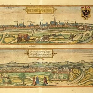
Map of Dresden and Leipzig from Civitates Orbis Terrarum by Georg Braun, 1541-1622 and Franz Hogenberg, 1540-1590, engraving

![]()
Wall Art and Photo Gifts from Universal Images Group (UIG)
Map of Dresden and Leipzig from Civitates Orbis Terrarum by Georg Braun, 1541-1622 and Franz Hogenberg, 1540-1590, engraving
Cartography, Germany, 16th century. Map of Dresden and Leipzig. From Civitates Orbis Terrarum by Georg Braun (1541-1622) and Franz Hogenberg (1540-1590), Cologne. Engraving
Universal Images Group (UIG) manages distribution for many leading specialist agencies worldwide
Media ID 9571195
© DEA / R. MERLO
16th Century Coat Of Arms Dresden Elevated View Germany Latin Script Leipzig Manuscript River
EDITORS COMMENTS
This print showcases a remarkable piece of cartographic history - the Map of Dresden and Leipzig from Civitates Orbis Terrarum by Georg Braun and Franz Hogenberg. Created in the 16th century, this engraving offers a fascinating glimpse into the physical geography and landscape of Germany during that time. The intricate details captured in this studio shot highlight the expertise and artistry involved in creating such maps. The coat of arms proudly displayed on the map signifies its significance as an official representation of these two cities. With its elevated view, we are transported back in time to witness how Dresden and Leipzig appeared centuries ago. The meandering river depicted on the map adds depth to our understanding of their geographical layout. This manuscript serves not only as a navigational tool but also as an artistic masterpiece. Its Latin script further emphasizes its historical context, reminding us of the language commonly used during that era. While devoid of human representation, this photograph print allows us to appreciate both the technical skill employed by Braun and Hogenberg and their dedication to accurately capturing these cities' features. As we gaze upon this extraordinary artwork, we are reminded once again that maps hold within them not just geographic information but also stories about our past.
MADE IN THE USA
Safe Shipping with 30 Day Money Back Guarantee
FREE PERSONALISATION*
We are proud to offer a range of customisation features including Personalised Captions, Color Filters and Picture Zoom Tools
SECURE PAYMENTS
We happily accept a wide range of payment options so you can pay for the things you need in the way that is most convenient for you
* Options may vary by product and licensing agreement. Zoomed Pictures can be adjusted in the Cart.