Home > Arts > Artists > C > Vincenzo Maria Coronelli
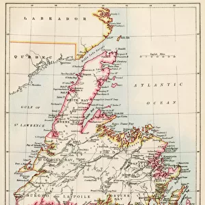
Map of Eastern Canada and Newfoundland, drawing by Vincenzo Maria Coronelli, 1692

![]()
Wall Art and Photo Gifts from Universal Images Group (UIG)
Map of Eastern Canada and Newfoundland, drawing by Vincenzo Maria Coronelli, 1692
Cartography, 17th century. Map of Eastern Canada and Newfoundland, drawn by Vincenzo Maria Coronelli in 1692
Universal Images Group (UIG) manages distribution for many leading specialist agencies worldwide
Media ID 9571157
© DEA / A. DAGLI ORTI
1692 17th Century Aerial View Border Canada Coastline Direction Drawing Guidance Island Navigational Equipment Newfoundland Text Western Script Non Urban Scene
FEATURES IN THESE COLLECTIONS
> Aerial Photography
> Related Images
> Arts
> Art Movements
> Landscapes
> Arts
> Artists
> C
> Vincenzo Maria Coronelli
> Arts
> Contemporary art
> Landscapes
> Sculptures
> Arts
> Contemporary art
> Sculpture
> Landscape paintings
> Arts
> Landscape paintings
> Landscape art
> Landscape paintings
> Arts
> Landscape paintings
> Landscape art
> Arts
> Street art graffiti
> Urban art
> Landscape paintings
> North America
> Canada
> Maps
> Universal Images Group (UIG)
> Art
> Painting, Sculpture & Prints
> Cartography
EDITORS COMMENTS
This print showcases a remarkable piece of cartographic history - the "Map of Eastern Canada and Newfoundland" drawn by Vincenzo Maria Coronelli in 1692. The intricate details and exquisite craftsmanship of this 17th-century map are truly awe-inspiring. As we gaze upon this island, Canada comes to life before our eyes. The vast expanse of land is beautifully depicted, with its rugged coastline embracing the majestic Atlantic Ocean. Every bay, border, and topographical feature has been meticulously rendered, offering us a glimpse into the physical geography of this enchanting region. Coronelli's masterful artistry extends beyond mere representation; his map serves as both guidance and inspiration for travelers seeking new horizons. Its carefully inscribed text provides valuable navigational information while evoking a sense of adventure that awaits those who dare to explore these uncharted territories. The aerial view presented here allows us to appreciate the sheer magnitude and diversity of Eastern Canada and Newfoundland. From sea to shining sea, this landscape beckons explorers with its untamed beauty and rich history. This artwork transports us back in time, reminding us of an era when maps were not just tools but works of art themselves. With Western script adorning its borders and navigational equipment scattered throughout, it stands as a testament to mankind's ceaseless quest for knowledge about our world. In this non-urban scene devoid of people, we can almost hear the whispers from centuries past echoing through time. Let us cherish this glimpse
MADE IN THE USA
Safe Shipping with 30 Day Money Back Guarantee
FREE PERSONALISATION*
We are proud to offer a range of customisation features including Personalised Captions, Color Filters and Picture Zoom Tools
SECURE PAYMENTS
We happily accept a wide range of payment options so you can pay for the things you need in the way that is most convenient for you
* Options may vary by product and licensing agreement. Zoomed Pictures can be adjusted in the Cart.