Home > Universal Images Group (UIG) > Art > Painting, Sculpture & Prints > Cartography
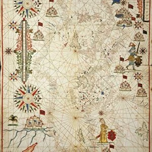
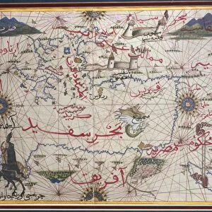
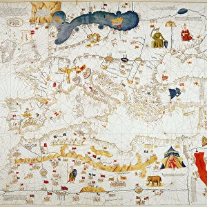
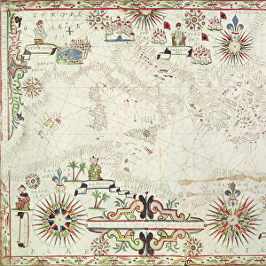
Map of Mediterranean and Black Sea, by French admiral Albin Roussin, 1654

![]()
Wall Art and Photo Gifts from Universal Images Group (UIG)
Map of Mediterranean and Black Sea, by French admiral Albin Roussin, 1654
Cartography, 17th century. Map of the Mediterranean and the Black Sea, by French admiral Albin Roussin, 1654
Universal Images Group (UIG) manages distribution for many leading specialist agencies worldwide
Media ID 9572119
© DEA / M. SEEMULLER
17th Century Black Sea Coastline Coat Of Arms Compass Rose Mediterranean Sea Peninsula Western Script
EDITORS COMMENTS
This print showcases a remarkable piece of cartography from the 17th century, featuring the "Map of Mediterranean and Black Sea" by French admiral Albin Roussin in 1654. The full-length map is beautifully preserved, displaying intricate details that transport us back to a time when exploration and navigation were at their peak. The map, created with meticulous precision, portrays the vastness of the Mediterranean Sea and its surrounding territories. With its horizontal orientation, it allows us to trace the coastlines of various peninsulas along both sides of this historic sea. The inclusion of the Black Sea adds an additional layer of intrigue to this masterpiece. Admiral Albin Roussin's expertise in cartography shines through as he skillfully incorporates elements such as a compass rose and Western script annotations into his work. These additions not only enhance navigational understanding but also contribute to the artistic value of this illustration. As we delve into this studio shot photograph, devoid of any human presence, we are reminded that history has left indelible imprints on our world. This artful creation serves as a testament to mankind's insatiable curiosity for exploration during centuries past. With its coat-of-arms symbolizing nobility and authority, this print stands as a timeless reminder that maps have always held immense power - guiding sailors across treacherous waters while simultaneously preserving historical knowledge for generations to come.
MADE IN THE USA
Safe Shipping with 30 Day Money Back Guarantee
FREE PERSONALISATION*
We are proud to offer a range of customisation features including Personalised Captions, Color Filters and Picture Zoom Tools
SECURE PAYMENTS
We happily accept a wide range of payment options so you can pay for the things you need in the way that is most convenient for you
* Options may vary by product and licensing agreement. Zoomed Pictures can be adjusted in the Cart.