Home > Europe > Portugal > Maps
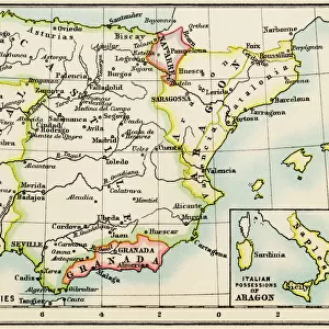
Nautical chart of the Balearic Islands, the Iberian Peninsula, and the north-western coast of Africa, detail of the first chart, from a nautical atlas of the Mediterranean Sea in three charts, by Pietro Giovanni Prunus, 1651

![]()
Wall Art and Photo Gifts from Universal Images Group (UIG)
Nautical chart of the Balearic Islands, the Iberian Peninsula, and the north-western coast of Africa, detail of the first chart, from a nautical atlas of the Mediterranean Sea in three charts, by Pietro Giovanni Prunus, 1651
Cartography, 17th century. Nautical chart of the Balearic Islands, the Iberian Peninsula, and the north-western coast of Africa. Detail of the first chart, from a nautical atlas of the Mediterranean Sea in three charts, by Pietro Giovanni Prunus, 1651. Cm 41.6x28
Universal Images Group (UIG) manages distribution for many leading specialist agencies worldwide
Media ID 9503733
© DEA / A. DAGLI ORTI
17th Century Africa Coastline Compass Rose Geography Mediterranean Sea Palm Tree Pietro Giovanni Prunus Portugal Spain Western Script Animal Representation
FEATURES IN THESE COLLECTIONS
> Africa
> Related Images
> Architecture
> Country
> Africa
> Architecture
> Country
> Portugal
> Architecture
> Country
> Spain
> Architecture
> Styles
> Mediterranean Architecture
> Europe
> Portugal
> Paintings
> Europe
> Portugal
> Sculptures
> Universal Images Group (UIG)
> Art
> Painting, Sculpture & Prints
> Cartography
EDITORS COMMENTS
This print showcases a stunning nautical chart from the 17th century, meticulously crafted by Pietro Giovanni Prunus in 1651. The intricate detail of this map provides an enchanting glimpse into the Balearic Islands, the Iberian Peninsula, and the north-western coast of Africa. With its rich historical significance, this piece offers a fascinating insight into cartography during that era. Measuring at approximately 41.6x28 cm, this antique treasure transports us back in time to an age when exploration and navigation were paramount. The artistry displayed is truly remarkable as it beautifully captures the essence of these coastal regions with precision and accuracy. As we delve deeper into this masterpiece, our eyes are drawn to various elements such as palm trees lining the shores, a compass rose indicating cardinal directions, and even animal representations scattered throughout. These subtle touches add a touch of whimsy amidst the scientific nature of cartography. The use of Western script further emphasizes how maps served not only practical purposes but also acted as works of art during this period. It is through pieces like these that we can appreciate both their aesthetic beauty and their invaluable contribution to our understanding of geography and history. With no people present within the frame, we are left to marvel at Prunus' skillful craftsmanship on its own merits. This print serves as a testament to his talent while offering viewers an opportunity to immerse themselves in centuries-old maritime knowledge and exploration.
MADE IN THE USA
Safe Shipping with 30 Day Money Back Guarantee
FREE PERSONALISATION*
We are proud to offer a range of customisation features including Personalised Captions, Color Filters and Picture Zoom Tools
SECURE PAYMENTS
We happily accept a wide range of payment options so you can pay for the things you need in the way that is most convenient for you
* Options may vary by product and licensing agreement. Zoomed Pictures can be adjusted in the Cart.