Home > Asia > Israel > Maps
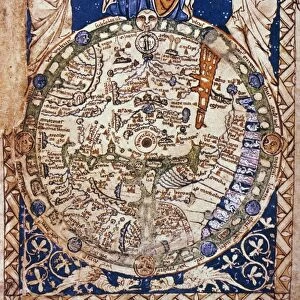
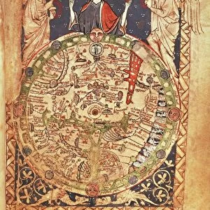
Map of Christian world with Jerusalem placed at its center

![]()
Wall Art and Photo Gifts from Universal Images Group (UIG)
Map of Christian world with Jerusalem placed at its center
Cartography, 14th century. Map of the Christian world with Jerusalem placed at its center
Universal Images Group (UIG) manages distribution for many leading specialist agencies worldwide
Media ID 9590725
© DEA PICTURE LIBRARY
Circle Geography Geometric Halo Israel Jerusalem Jesus Christ Saint Three People Western Script World Map
FEATURES IN THESE COLLECTIONS
> Universal Images Group (UIG)
> Art
> Painting, Sculpture & Prints
> Illustration And Painting
EDITORS COMMENTS
This 14th-century map of the Christian world, with Jerusalem positioned at its center, is a remarkable piece of cartography that beautifully captures the essence of Christianity's historical and spiritual significance. The intricate pattern and geometric precision employed in this artwork showcase the meticulous craftsmanship of the time. The haloed figure at the heart of this map represents Jesus Christ himself, symbolizing his divine presence as central to Christian faith. Surrounding him are three men, possibly saints or apostles, adding an air of reverence to this sacred depiction. Their vertical positioning emphasizes their connection between heaven and earth. The topography depicted on this ancient map provides a glimpse into how people perceived geography during that era. It serves as a testament to their understanding of the world beyond their immediate surroundings. Jerusalem's prominent placement signifies its importance as a holy city for Christians worldwide. As an illustration and painting, this print not only offers historical insights but also showcases artistic brilliance through its delicate details and use of Western script. Its rich colors and fine lines make it visually stunning while conveying invaluable information about religious history. This print from Universal Images Group (UIG) allows us to appreciate both the artistry involved in creating such maps centuries ago and gain knowledge about our collective past. It serves as a reminder that even in today's digital age, there is immense value in preserving tangible artifacts that connect us with our roots.
MADE IN THE USA
Safe Shipping with 30 Day Money Back Guarantee
FREE PERSONALISATION*
We are proud to offer a range of customisation features including Personalised Captions, Color Filters and Picture Zoom Tools
SECURE PAYMENTS
We happily accept a wide range of payment options so you can pay for the things you need in the way that is most convenient for you
* Options may vary by product and licensing agreement. Zoomed Pictures can be adjusted in the Cart.