Home > Europe > United Kingdom > England > Maps
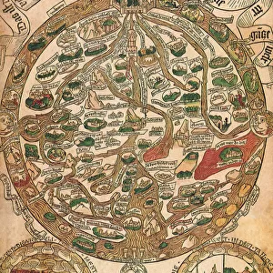
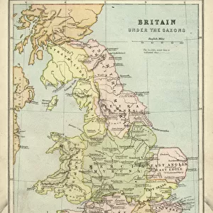
Map of England

![]()
Wall Art and Photo Gifts from Universal Images Group (UIG)
Map of England
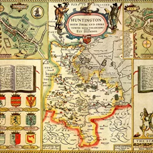
Map of England 1612
Universal Images Group (UIG) manages distribution for many leading specialist agencies worldwide
Media ID 20165187
17th Century America Antiquarian Antiquarian Maps North South Travels Treks Trips Voyage 1610s
FEATURES IN THESE COLLECTIONS
> Europe
> United Kingdom
> England
> Maps
> Maps and Charts
> Related Images
> North America
> Related Images
> South America
> Related Images
> Universal Images Group (UIG)
> History
> Historical Maps
EDITORS COMMENTS
This print showcases the "Map of England (1612)" in all its historical glory. Dating back to the 17th century, this antique map takes us on a mesmerizing journey through time and space. With intricate details and exquisite craftsmanship, it offers a fascinating glimpse into the cartographic artistry of that era. As we delve into this piece, our eyes are immediately drawn to the beautifully illustrated landscapes of England. From the rolling hills and lush green fields in the south to the rugged terrains of the north, every corner is meticulously depicted with utmost precision. This map serves as a testament to both exploration and documentation during an age when voyages were celebrated endeavors. The Map of England (1612) not only captures geographical information but also provides insights into cultural nuances prevalent at that time. It invites us to imagine what life was like for those who traversed these lands centuries ago - their treks, travels, and adventures etched onto this very canvas. With its rich history and undeniable charm, this antiquarian masterpiece from Universal Images Group (UIG) transports us back in time. It reminds us of how far we have come while igniting a sense of curiosity about our past. Whether you are an avid collector or simply appreciate fine artistry, this print is sure to captivate your imagination and spark conversations about bygone eras for years to come.
MADE IN THE USA
Safe Shipping with 30 Day Money Back Guarantee
FREE PERSONALISATION*
We are proud to offer a range of customisation features including Personalised Captions, Color Filters and Picture Zoom Tools
SECURE PAYMENTS
We happily accept a wide range of payment options so you can pay for the things you need in the way that is most convenient for you
* Options may vary by product and licensing agreement. Zoomed Pictures can be adjusted in the Cart.