Home > Aerial Photography > Related Images
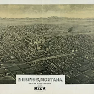
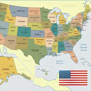
Billings Montana US City Street Map

![]()
Wall Art and Photo Gifts from Fine Art Storehouse
Billings Montana US City Street Map
Vector Illustration of a City Street Map of Billings, Montana, USA. Scale 1:60, 000.
All source data is in the public domain.
U.S. Geological Survey, US Topo
Used Layers:
USGS The National Map: National Hydrography Dataset (NHD)
USGS The National Map: National Transportation Dataset (NTD)
Unleash your creativity and transform your space into a visual masterpiece!
Frank Ramspott
Media ID 15054915
© Frank Ramspott, all rights reserved
Aerial View City Map Computer Graphic Directly Above Downtown District Gray Montana Road Map Text Yellowstone River Billings Digitally Generated Image Green Color White Color
FEATURES IN THESE COLLECTIONS
> Aerial Photography
> Related Images
> Animals
> Insects
> Hemiptera
> Green Scale
> Arts
> Contemporary art
> Digital artwork
> Street art
> Arts
> Landscape paintings
> Waterfall and river artworks
> River artworks
> Arts
> Portraits
> Pop art gallery
> Street art portraits
> Arts
> Street art graffiti
> Digital art
> Digital paintings
> Arts
> Street art graffiti
> Digital art
> Vector illustrations
> Fine Art Storehouse
> Map
> Street Maps
> Fine Art Storehouse
> Map
> USA Maps
> Maps and Charts
> Geological Map
> Maps and Charts
> Related Images
> North America
> United States of America
> Lakes
> Related Images
EDITORS COMMENTS
This print showcases a meticulously detailed vector illustration of the vibrant city street map of Billings, Montana, USA. With a scale of 1:60,000, every intricate aspect is beautifully captured in this artwork. The source data used for this creation is from the public domain and provided by the U. S. Geological Survey's National Map, including their National Hydrography Dataset (NHD) and National Transportation Dataset (NTD). The image depicts various elements that define the essence of Billings - from its picturesque Yellowstone River flowing gracefully through the city to its bustling downtown district filled with life and energy. The presence of a serene lake adds an extra touch of tranquility amidst the urban landscape. Rendered in striking colors such as gray, blue, white, and green, this digitally generated image offers an aerial view directly above Billings' streets. It flawlessly combines cartography with modern design techniques to create a visually stunning representation. Perfectly suited for any space or decor style, this print brings together artistry and functionality seamlessly. Its absence of people allows viewers to focus solely on appreciating the physical geography and intricate road network that makes up this remarkable cityscape. Created by talented artist Frank Ramspott exclusively for Fine Art Storehouse, this unique piece exemplifies his mastery in creating visually captivating maps that transcend traditional boundaries.
MADE IN THE USA
Safe Shipping with 30 Day Money Back Guarantee
FREE PERSONALISATION*
We are proud to offer a range of customisation features including Personalised Captions, Color Filters and Picture Zoom Tools
SECURE PAYMENTS
We happily accept a wide range of payment options so you can pay for the things you need in the way that is most convenient for you
* Options may vary by product and licensing agreement. Zoomed Pictures can be adjusted in the Cart.